↓
 

ISSN 1993-3916

Arid Ecosystems

The “Arid Ecosystems” journal was organized by the decision of General Biology Division of the Russian Academy of Sciences.

  •  Home
  • Preprint
  • Contacts
  • Open Access 
  • Archive
    • Issues 1990s
      • Issues for 1995
      • Issues for 1996
      • Issues for 1997
      • Issues for 1998
      • Issues for 1999
      • Issues for 2000
    • Issues 2000s
      • Issues for 2001
      • Issues for 2002
      • Issues for 2003
      • Issues for 2004
      • Issues for 2005
      • Issues for 2006
      • Issues for 2007
      • Issues for 2008
      • Issues for 2009
      • Issues for 2010
    • Issues 2010s
      • Issues for 2011
      • Issues for 2012
      • Issues for 2013
      • Issues for 2014
      • Issues for 2015
      • Issues for 2016
      • Issues for 2017
      • Issues for 2018
      • Issues for 2019
    • Issues 2020s
      • Issues for 2020
      • Issues for 2021
      • Issues for 2022

Архив рубрики: article-1-2020

Навигация по записям

← Предыдущие записи

THE EVOLUTION OF TECHNOLOGY IN AGRICULTURE: FROM “GRAY” TO “GREEN”

Arid Ecosystems

Gusev E.M. THE EVOLUTION OF TECHNOLOGY IN AGRICULTURE: FROM “GRAY” TO “GREEN” // Arid ecosystems. 2020. V. 26. № 1 (82). P. 3-12 . | PDF

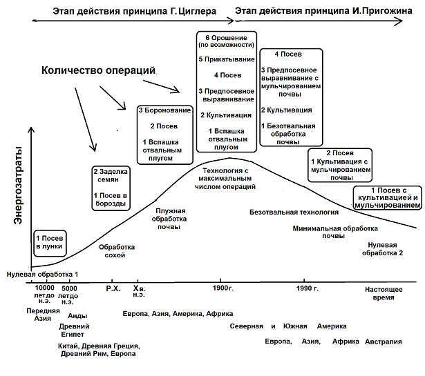
The evolution of agricultural technologies in the development of human civilization is under consideration. As we can see in the XX century a new stage of tillage technology has begun, connected with the transition from “gray” extensive technologies for managing natural resources, which are strictly focused only on short-term economic feasibility, to non-traditional (environmental, nature-like, nature-based, “green”) farming technologies. There was a natural transition of strategy of human development, based on the principle of Ziegler’s maximum entropy production, to Prigogine’s minimum production strategy, based on the rationalization of the use of available nature resources by the human population. The rationalization is based on nature-based technologies employed by people to use natural resources. On the example of a long-term biospheric experiment in the development of agricultural technologies, the theoretical substantiation of the inevitability of “green farming” has been confirmed. “Green farming” is characterized by more economical methods of tillage: partial or complete rejection of dump plowing, lack of vertical mixing of the arable layer, minimal soil disturbance by agricultural machines and mandatory soil mulching (no-till or mulch tillage) in order to preserve soil moisture and reduce soil erosion. The system of zero tillage (associated with the absence of interference with natural soil formation processes) is a modern farming system, in which practically tillage is absent and soil surface is covered with specially crushed plant residues – mulch. It is illustrated that at present, no-till direct seeding and mulching technology is being introduced in various regions of the planet, while using fine, surface loosening or even a complete abandonment of tillage. It has been shown that the use of green farming technology leads not only to rationalization of use energy and soil resources, but also economy of water resources, the situation with which is becoming more intense for human civilization.

Keywords: Ziegler’s principle of maximum entropy production, Prigogine’s principle of minimum entropy production, the evolution of farming technologies, green farming, no-till farming, mulching.

DOI: 10.24411/1993-3916-2020-10078

LANDSCAPE APPROACH TO MODELLING SOIL AND VEGETATION MOISTURE DYNAMICS USING REMOTE SENSING TECHNICS

Arid Ecosystems

T.I. Kharitonova, Surkov N.V. LANDSCAPE APPROACH TO MODELLING SOIL AND VEGETATION MOISTURE DYNAMICS USING REMOTE SENSING TECHNICS // Arid ecosystems. 2020. V. 26. № 1 (82). P. 13-20. | PDF

The paper discusses remote sensing methods of describing the intra-seasonal dynamics of soil and vegetation moisture content. Field moisture of soil and vegetation cover is described by an integral indicator, which combines values of water content in upper horizon of the soil (5-10 cm), herbaceous phytomass and tree leaves. The field moisture integral indicator demonstrates the reliable relationship with the Normalized Difference Water Index (NDWI), with the coefficient of determination R2 reaching values of 0,91 for certain land cover classes. The most significant factors determining the loss of moisture during the summer period are the volume of photosynthetically active phytomass, potential incoming solar radiation during the study period and the water supply in soil and vegetation at the beginning of vegetation. These factors describe 67% of the NDWI difference from May to August 2016 in forests sites and 89% in steppes. The obtained results could be used to search for fire-hazardous areas in steppes and forests and to monitor vineyards.

Keywords: Karadag Nature reserve, soil and vegetation moisture content, NDWI, semi-arid landscapes of Crimea.

DOI: 10.24411/1993-3916-2020-10079

POPULATION AND COMMUNITY STRUCTURE PATTERN OF JUNIPEROUSPOLYCARPOS K. KOCH WITH CLIMATE CHANGE EFFECT IN THE COLD DESERT TRANS HIMALAYAN REGION, INDIA

Arid Ecosystems

Singh A.,  Samant S.S. POPULATION AND COMMUNITY STRUCTURE PATTERN OF JUNIPEROUSPOLYCARPOS K. KOCH WITH CLIMATE CHANGE EFFECT IN THE COLD DESERT TRANS HIMALAYAN REGION, INDIA // Arid ecosystems. 2020. V. 26. № 1 (82). P. 21-32 . | PDF

Juniperus polycarpos L. is one of the most threatened and livelihood plant species of the Himalayan region. The present study provides information about monitoring of its populations and proliferation rate in high altitude regions of Trans Himalaya. The survey revealed comprehensive information on J. polycarpos such as distribution range, habitat characteristics, composition, structural pattern, population size, uses and diversity status. Its distribution and density were maximal in pure forest habitats as compared to mixed habitats recorded. Middle forest altitudinal zone (3100-3500 m for dominant J. polycarpos community and 2710-3100 m for mixed communities) showed suitability for its growth and high density. The occurrence of species above treeline altitudinal zone (4100 m) indicates effect by climate change. A total 281 species (158 genera, 48 families, 37.04% native, 2.06% endemic, 23.87% near-endemic, 74.44% economically important and 20.28% threatened species) were recorded within its populations. Frequent monitoring of populations under climate change scenarios is suggested.

Keywords: populations structure, diversity, climate change studies, ethno-botanical studies, nativity, threatened species.

DOI: 10.24411/1993-3916-2020-10080

TIME AND REASONS OF SOLONETZ PROCESS’ GENESIS IN THE SOILS OF THE DESERTED STEPPES IN THE SOUTHEASTERN PART OF EAST EUROPEAN PLAIN

Arid Ecosystems

Borisov A.V., Alekseyev A.O. TIME AND REASONS OF SOLONETZ PROCESS’ GENESIS IN THE SOILS OF THE DESERTED STEPPES IN THE SOUTHEASTERN PART OF EAST EUROPEAN PLAIN // Arid ecosystems. 2020. V. 26. № 1 (82). P. 33-42 . | PDF

In this article we study the time frame and role of the anthropogenic factor in the genesis of the solonetz process in the soils of the deserted steppes in the southeastern part of East European Plain. Basing on the research of the soils of different ages buried under the barrows of Bronze Age and Middle Ages (6200-700 years ago) in the boundaries of Sal-Manych ridge, we found out that before the 3rd millennium BC those soils had no signs of solonetz process on macro level. First solonetz in the region started to form 4800-4700 years ago, which chronologically matches the beginning of climate aridization intensification. During that period the deserted steppes were actively inhabited by cattlemen, who were breeding small cattle, which in its turn caused the pressure on land and steppe ecosystems. In this article we study the possible cause and effect relations in “climate – agricultural” model – solonetz process” system.

Keywords: desert-steppe zone, Sal-Manych ridge, soils, solonetz process, barrows, Bronze Age, aridization, cattle, grazing.

DOI: 10.24411/1993-3916-2020-10081

PRESERVED STEPPED AREAS AS A BASIS FOR THE FUTURE ECOLOGICAL FRAMEWORK OF BELGOROD REGION

Arid Ecosystems

Tishkov A.A., Belonovskaya E.A., Zolotukhin N.I., Titova S.V.,  Tsarevskaya N.G.,  Chendev Y.G. PRESERVED STEPPED AREAS AS A BASIS FOR THE FUTURE ECOLOGICAL FRAMEWORK OF BELGOROD REGION // Arid ecosystems. 2020. V. 26. № 1 (82). P. 43-53 . | PDF

Belgorod Oblast is a region of ancient economic development with the highest level of agricultural land use in Russia and, accordingly, anthropogenic transformation of zonal vegetation and black soils. Despite all the efforts during the recent years to improve the territorial protection of nature in the region, all categories of protected areas occupy only 1.8% of the territory, which is one of the lowest rates among the subjects of the Russian Federation. Steppe areas in protected areas occupy less than 10% of the area of all protected areas, i.e. 0.2% of the area of the region, which can’t serve as a basis for the conservation of steppe biodiversity and the formation of the ecological framework of the region, where the zonal type of vegetation − steppe. The article presents a historical analysis of the transformation of steppe vegetation in the region, the results of the inventory using remote sensing of the remaining areas of the steppes, assessing the potential of their flora for the development of secondary successions, effective for the conservation of steppe biodiversity of the regional network of protected areas and the formation of ecological framework. It is shown that the identified 699 sites with preserved zonal steppe vegetation (about 39 thousand hectares), small-contour and fragmented, are located on the inconveniences and heavily eroded slopes of beams and dens. Without special measures, they are not able to become the basis of the ecological framework. Thus, we propose approaches and methods of stimulating restoration of steppes and man-made post-agrogenic soils of the region.

Keywords: steppe, forest-steppe, meadow, real and Cretaceous steppes, Belgorod Region, protected area, ecological framework, black soils, regenerative succession, succession system, Belogorie nature reserve.

DOI: 10.24411/1993-3916-2020-10082

CHANGES IN THE COMPOSITION OF VOLGA-AKHTUBA FLOODPLAIN AFTER THE BEGINNING OF FLOW REGULATION ON VOLGA RIVER

Arid Ecosystems

Golub V.B., Chuvashov A.V., Bondareva V.V., Gerasimova K.A., Nikolaychuk L.F. CHANGES IN THE COMPOSITION OF VOLGA-AKHTUBA FLOODPLAIN AFTER THE BEGINNING OF FLOW REGULATION ON VOLGA RIVER // Arid ecosystems. 2020. V. 26. № 1 (82). P. 54-61 . | PDF

Four stationary transects, made in the Volga-Akhtuba floodplain by the Caspian expedition of M.V. Lomonosov Moscow State University in 1954-1955, were studied. The transects were re-examined in 1982 and 2008-2013. The occurrence of the most common plant species during each of the three study periods was evaluated. It was stated that all transects were affected by introduction of xerophytic and ruderal flora, variously across different sections of the Volga-Akhtuba floodplain. Mostly it can be seen near the Volgograd hydroelectric station and in places where the valley is narrowing. The main reasons for xerophytic and ruderal species appearance are the reduction in height and duration of floods after the regulation of Volga water flow, high local grazing and recreation load. In the northern part of the floodplain, invasions into the natural phytocenoses of the adventitious species Fraxinus pennsylvanica, Bidens frondosa, Conyza canadensis, Xanthium strumarium made significant changes in vegetation cover.

Keywords: Lower Volga Valley, regulation of water flow, vegetation xerophytization, ruderal species.

DOI: 10.24411/1993-3916-2020-10083

MELIORATIVE EFFICIENCY OF THE BELT OF SHRUBS ON THE ARID PASTURES OF SOUTHERN RUSSIA

Arid Ecosystems

Tyutyuma N.V., Bulakhtina G.K., Kudryashov A.V., Kudryashova N.I. MELIORATIVE EFFICIENCY OF THE BELT OF SHRUBS ON THE ARID PASTURES OF SOUTHERN RUSSIA // Arid ecosystems. 2020. V. 26. № 1 (82). P. 62-68 . | PDF

In this article we present the long-term study (2008-2018) of the influence of a belt of shrubs on the vegetation cover of semi-deserted and degraded pastures. We investigated the changes of snow cover depth during the winter period, productive soil moisture storage, species composition and arid pastures productivity in the dynamics of growth and development of the belt of shrubs. These experiments were carried out according to the methods developed by the All-Russian Research Institute of Agricultural Afforestation (1973), the All-Russian Research Institute of Forages (2015) and B.A. Dospekhov (1985). In comparison with a natural pasture without belts it was revealed that the snow cover depth was growing 3.5-11 times depending on the increased height of Krascheninnikovia shrubs and the amount of precipitation; soil moisture storage increased by 7.2-9.1 mm in the first 5 years, and by 8.8-24.8 mm when the belt’s height was more than 1 m; in the next 10 years the amount of dominant plant species increased by 4 species in the area with the belt of shrubs; pasture productivity increased 1.3-3.9 times in the 3rd years of Krascheninnikovia shrubs vegetation.

Keywords: phytocenosis of pastures, degradation, desertification, belt of shrubs, productive soil moisture storage.

DOI: 10.24411/1993-3916-2020-10084

TO THE QUESTION OF THE INDICATOR OF SOILS ASSIMILATION POTENTIAL AS A COMPOSITE PART OF THE SOIL PASSPORT AND LANDSCAPES ASSIMILATION POTENTIAL

Arid Ecosystems

Ismailov N.M., Najafova S.I., Kayserovskaya F., Gasymova A.S. TO THE QUESTION OF THE INDICATOR OF SOILS ASSIMILATION POTENTIAL AS A COMPOSITE PART OF THE SOIL PASSPORT AND LANDSCAPES ASSIMILATION POTENTIAL // Arid ecosystems. 2020. V. 26. № 1 (82). P. 69-75 . | PDF

Using the complex comparative soil-biological method for the first time, the average annual assimilation volumes of hydrocarbon pollution in the main soil types of various bioclimatic landscape zones of Azerbaijan were evaluated. The results of the research allowed, in the first approximation, to identify regions with potentially the highest (mountain brown, chestnut and mountain black soils) and the most vulnerable assimilation potential − gray-brown and gray soil. The results of the conducted studies show the possibility and necessity of introducing in the “Soil Passport” indicators of soils data on their assimilation potential with respect to a particular pollutant.

Keywords: soil, pollution, assimilation potential, coefficient of mineralization, passport of soils, scientific basis of nature management.

DOI: 10.24411/1993-3916-2020-10085

SPATIAL-TEMPORAL DYNAMICS OF THE STATE OF MICROBIAL COMMUNITIES IN THE STEPPE SOILS OF THE VOLGA-DON INTERFLUVE

Arid Ecosystems

Demkina T.S. SPATIAL-TEMPORAL DYNAMICS OF THE STATE OF MICROBIAL COMMUNITIES IN THE STEPPE SOILS OF THE VOLGA-DON INTERFLUVE // Arid ecosystems. 2020. V. 26. № 1 (82). P. 76-83 . | PDF

Soil microorganisms are the essential part of soil composition. Almost every soil process depends on the microorganisms’ activity, in one way or another. That is why characteristic of microbial communities is one of the most important diagnostic indices representing the conditions for soil formation. Paleosols maintain some features from the moment of their burial, which can be found in some of the parameters of their microbial community, such as the active biomass of microorganisms, ecologic and trophic structure of community, oligotrophy index etc. We studied microbial communities from the soils of different ages and different natural areas of Volga-Don interfluve, to determine the patterns of their spatial-temporal changes in connection with the current conditions of soil formation. We found out that the characteristics of communities of the modern soils in the dry-steppe and deserted-steppe areas in the south-east of the East European Plain mostly determine the specificity of the local conditions for soil formation. Thus, the soils of one sub-class, while being under different geomorphological and landscape conditions, can vary in their microbiological parameters. Or the characteristics of microbial communities of different soils can be very close, if the latter are related to the similar reliefs, soil-forming rocks and ground water level. Conditions of those communities during different historical periods are mostly determined by the patterns of evolution of specific soil areal (landscape) and bioclimatic changes during the century. Therefore, the local specificity is formed under the dynamics of the microbial communities’ conditions and their structural and functional organization.

Keywords: steppe, chestnut and light chestnut soils of different ages, microbial communities.

DOI: 10.24411/1993-3916-2020-10086

THE METHODOLOGICAL APPROACHES TO IRRIGATED LANDS STATE ESTIMATION IN THE SOUTH OF EUROPEAN RUSSIA, BASED ON SPACE IMAGERY

Arid Ecosystems

Gorokhova I.N., Pankova Ye.I., Chursin I.N. THE METHODOLOGICAL APPROACHES TO IRRIGATED LANDS STATE ESTIMATION IN THE SOUTH OF EUROPEAN RUSSIA, BASED ON SPACE IMAGERY // Arid ecosystems. 2020. V. 26. № 1 (82). P. 84-93 . | PDF

Methodological approaches to irrigated lands monitoring in the south of the European Russia based on satellite imagery from the Landsat-8 satellite are presented. The basis of the methodological approaches was developed on the background of the research experience obtained in the Volgograd region. Visual and automated methods for the irrigated soils interpretation and their properties are shown. As a result of irrigated lands interpretation on the basis of materials from space imagery, the following tasks were solved:1) determination of the areas of irrigated lands; 2) determination of the area of long-term layland on irrigated arrays; 3) determination of the irrigated areas under different crops; 4) determination of the genesis of the low-contrasting soil combinations on irrigated fields, which are, in turn, determined by the state of cultivated crops and soil properties. The conducted work is the first step towards creating of irrigated lands monitoring based on remote sensing. In addition to the above mentioned tasks, the results of the investigation were: the choice of the optimal type and temporal scales of space imagery, the developed interpretation features for the condition of crops and the properties of irrigated soils, the technology of automated interpretation of satellite images for highlighting the spots of irrigated fields based on the «decision trees» algorithm.

Keywords: monitoring, irrigated lands, space imagery, interpretation features, automated classification.

DOI: 10.24411/1993-3916-2020-10087

Навигация по записям

← Предыдущие записи

About the Journal

  • General Information
  • Open Access 
  • Preprint
  • Topics of the journal
  • Editoral Board
  • Editorial Policy
  • Editorial Ethics

Articles Supplying

  • Rules of Manuscripts Supplying
  • Articles Design
  • Article Structure
  • Guidens for Writing an Article
  • Articles Translation

Review of manuscripts

  • Review of manuscripts

Archive

  • 1990s editions
  • 2000s editions
  • 2010s editions
  • 2020s editions
    • Issues for 2020
    • Issues for 2021
    • Issues for 2022
  • Events

_______________________

©2023 - Arid Ecosystems - Weaver Xtreme Theme
↑