↓
 

ISSN 1993-3916

Arid Ecosystems

The “Arid Ecosystems” journal was organized by the decision of General Biology Division of the Russian Academy of Sciences.

  •  Home
  • Preprint
  • Contacts
  • Open Access 
  • Archive
    • Issues 1990s
      • Issues for 1995
      • Issues for 1996
      • Issues for 1997
      • Issues for 1998
      • Issues for 1999
      • Issues for 2000
    • Issues 2000s
      • Issues for 2001
      • Issues for 2002
      • Issues for 2003
      • Issues for 2004
      • Issues for 2005
      • Issues for 2006
      • Issues for 2007
      • Issues for 2008
      • Issues for 2009
      • Issues for 2010
    • Issues 2010s
      • Issues for 2011
      • Issues for 2012
      • Issues for 2013
      • Issues for 2014
      • Issues for 2015
      • Issues for 2016
      • Issues for 2017
      • Issues for 2018
      • Issues for 2019
    • Issues 2020s
      • Issues for 2020
      • Issues for 2021
      • Issues for 2022

Архив рубрики: article-3-2021

Навигация по записям

← Предыдущие записи

CHANGES IN THE WATER AVAILABILITY OF THE TERRITORY OF RIVER BASINS LOCATED IN DIFFERENT REGIONS OF THE GLOBE, DUE TO POSSIBLE CLIMATE CHANGES

Arid Ecosystems

Gusev E.M., Nasonova O.N., Kovalev E.E. CHANGES IN THE WATER AVAILABILITY OF THE TERRITORY OF RIVER BASINS LOCATED IN DIFFERENT REGIONS OF THE GLOBE, DUE TO POSSIBLE CLIMATE CHANGES // Arid ecosystems. 2021. V.27. № 3 (88). P. 3-15.

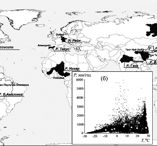
Scenario projections of changes in climatic water availability for vegetation (water availability index averaged over a climatic period (~ 30 years)), as well as changes in the variability of annual water availability for vegetation of the corresponding territories due to possible climate change in the 21st century for a number of large river basins of the globe, characterized by different natural conditions, were obtained using the land surface model SWAP developed at the Institute of Water Problems of the Russian Academy of Sciences. The ratio of the real annual transpiration to its potential value was used as an indicator of the water availability for plants. Eleven river basins (the Rhine, Tagus, Ganges, Lena, U. Yellow, U. Yangtze, Niger, Mackenzie, U. Mississippi, U. Amazon, and Darling) suggested within the framework of the International ISI-MIP project and located on different continents of the globe under different environmental conditions were used for the study. Meteorological forcing data to run the SWAP model were simulated by five General Climate Models (GCMs) for four climate change scenarios of the RCP-family up to the end of the 21st century.

It was shown that only five river basins (the Tagus, Ganges, Niger, U. Mississippi, and Darling basins) have the problems related to the water deficit. The other river basins are characterized by a humid and semi-humid type of climate, which will not change by the end of the XXI century. For the basins of the five abovementioned rivers, the change in the degree of their water availability due to possible climatic changes was analyzed in more detail. Changes in average (climatic) value of the annual water availability of these basins and in variability of water availability were investigated by means of construction of the integral distribution function of annual water availability for the historical and prognostic periods. It was shown that for the arid and semi-arid basins under study the degree of water availability by the end of the 21st century will be the same as for the historical period or even decrease.

Thus, for arid and semi-arid regions, the possible climate change in the 21st century will exacerbate the serious problem of the food security of mankind associated with the agricultural sector and water management. This problem will require an accelerated transition of human interaction with Nature to the principles of «green farming», which is based on application of nature-based technologies for using natural resources rationalizing the consumption of water, soil, energetic and other resources of the planet.

Keywords: water availability of vegetation, river basin, evapotranspiration, climate change RCP-scenarios, hydrological and climatic modelling, arid areas.

Acknowledgments. The authors are grateful to everyone, who organized the Water Section of the International ISI-MIP Project on a regional scale, for the provided data and materials for the river basins studied in this work.

Funding. This work was carried out within the state assignment of Water Problems Institute of the Russian Academy of Sciences, Theme No. 0126-2021-0001 (state registration No. 121040700170-9) “Development of a Methodological Base and Digital Technologies to Support Decision-Making for Ensuring the Water Security of Crimea” and Theme No. 0147-2018-0001 (state registration No. АААА-А18-118022090056-0) “Study and Modeling of Processes of the Land Hydrological Cycle, Hydrophysical and Hydrodynamic Processes, Formation Patterns of Resources of the Surface Water, Soil Water and Groundwater under Changing Natural Conditions”, as well as with the financial support of the Russian Science Foundation, grant No. 16-17-10039 “Calculations and Forecasts (Including Assessment of Their Uncertainty) of the Water Balance Components of the River Basins Located on Different Continents of the Globe”.

DOI: 10.24411/1993-3916-2021-10158

THE CLIMATE CHANGE IN THE EXPANSION RANGE OF WEST NILE FEVER IN RUSSIA: SPATIAL-TEMPORAL TRENDS EVALUATION

Arid Ecosystems

Zelikhina S.V., Shartova N.V., Mironova V.A., Varentsov M.I. THE CLIMATE CHANGE IN THE EXPANSION RANGE OF WEST NILE FEVER IN RUSSIA: SPATIAL-TEMPORAL TRENDS EVALUATION // Arid ecosystems. 2021. V.27. № 3 (88). P. 16-23.

This work aims to estimate the spatial-temporal trends of climatic conditions changes for the spread of West Nile fever (WNF) in the south of the European part of Russia. We used observations data with 58 weather stations (1997-2018) and data the ERA-Interim reanalysis (1981-2018). We assessed the suitability of climatic conditions for West Nile virus (WNV) transmission using the degree-day method. Based on the data obtained, we demonstrate the growth of the sums of effective temperatures (ET). The increase in the duration of the season of effective infectivity of mosquitoes was not tracked down. The changes in the sums ET coincide with the increase in the average air temperature for the epidemiological season. This creates favorable conditions for the development of the virus in the mosquito, as with an increase in ET the circulation of the virus is more efficient. The most favorable situation for the transmission of WNV is in the Caspian and Ciscaucasia region. In this territory, there is a further improvement in the conditions for the circulation of WNF due to an increase in the sums of ET. Compared to the Urals region, conditions suitable for the transmission of WNV are developing much faster in the central part of the European territory of Russia. It may lead to the further spread of WNV in this region.

Keywords: West Nile fever, West Nile virus, climate, temperature, climate changes, degree-day method, climatic trends.

Funding. This work was carried out with the financial support of the Russian Science Foundation, Project No. 17-77-20070 “Assessing and Forecasting the Bioclimatic Comfort of Russian Cities under the Climate Change in the XXI Century”, and as part of the development program of the Interdisciplinary Scientific and Educational School of Moscow State University “The planet future and the global environmental changes”.

DOI: 10.24411/1993-3916-2021-10159

THE MAJOR NODES OF A BIODIVERSITY AND PHYTOGEOGRAPHICAL PHENOMENA OF PLANT WORLD OF SOUTHERN SIBERIA

Arid Ecosystems

Namzalov B.B. THE MAJOR NODES OF A BIODIVERSITY AND PHYTOGEOGRAPHICAL PHENOMENA OF PLANT WORLD OF SOUTHERN SIBERIA // Arid ecosystems. 2021. V.27. № 3 (88). P. 24-36.

The most important nodes are distinguished as standards of plant biodiversity in various sectors of Southern Siberia: A – Saylyugem – Mongun-Taiga in Gorny Altai and Western Tuva; B – Sangilen-Darkhat in Southeast Tuva and Mongolia; C – Selenginsk-Daursky (Western Transbaikalia) in Buryatia. In the mountains of the Saylyugem ridge and Mongun-Taiga, there are many mountainous Central Asian species located on the eastern border of their ranges – the share of border species is up to 40% (Сoluria geoides, Potentilla lydiae, Allium pallasii, Lonicera microphylla, Artemisia obtusiloba  and others). This points to the historical links of this western sector of South Siberia with Middle and Central Asia. Endemic species that have the highest diversity index (60%) give originality to the flora of the Sangilen Highlands. The presence of boundary species as western and eastern geographic orientations, including Caragana jubata, Cymbaria dahurica, Echinops latifolius, Onosma gmelinii, Oxytropis tragacantoides, Lonicera microphylla and others, also indicate intense migration phenomena in the mountains of the Sangilen-Darhat node. The West Transbaikal node in the south of Buryatia, characterized by the presence of relics of the nemoral flora of East Asia, is of particular interest. These are Ulmus pumila, Armeniaca sibirica, Rhamnus erythroxylon, Filifolium sibiricum, Spodiopogon sibiricus, Saposhnikovia divaricata. According to this indicator, the flora of the Selenga Dauria has the highest level of diversity (40%).

The work reveals the features of floristic wealth and the diversity of the steppes of Transbaikalia and the Baikalia region, and the natural factors that cause them. It is shown, that this is a consequence of the ecotonic position of the territory (zonal-provincial), but also of the global climatic influence (Pacific, arid Central Asia). The complexity and variegation of vegetation in the steppes of Baikal Siberia gave us various interpretations of the boundaries of individual provinces and districts in geobotanical zoning schemes. The most complex is the vegetation of the steppes and forest-steppe of the Selenginsk midlands of Western Transbaikalia, which has been identified as a special buffer province.

Keywords: area, flora, endemic, relic and border species, nodes of biodiversity, Altai, Tuva, Western Transbaikalia.

Funding. This work was carried out with the financial support of the Russian Science Foundation for Basic Research, Project № 15-44-04112р_Siberia_a – «Relict and endemic plants of Transbaikalia: analysis of populations state, ecological mapping of refugium and perspectives of genetic fund preservation», Project № 16-04-20813 – «Rare plants and phytocenoses of Baikal region and adjacent territories».

DOI: 10.24411/1993-3916-2021-10160

DYNAMICS OF THE ECOLOGICAL STATE OF SOILS AND FLORA AFTER A FOREST FIRE IN THE EUROPEAN PART OF RUSSIA

Arid Ecosystems

Grigorievskaya A.Ya., Gorbunova Yu.S., Devyatova T.A. DYNAMICS OF THE ECOLOGICAL STATE OF SOILS AND FLORA AFTER A FOREST FIRE IN THE EUROPEAN PART OF RUSSIA // Arid ecosystems. 2021. V.27. № 3 (88). P. 37-44.

The 10-year dynamics of the catalase activity of leached chernozem was studied in order to determine the intensity and direction of redox processes in the post-pyrogenic ecosystem located in the forest-steppe of the European part of Russia. The results of studying the Pinus sylvestris formation with the coordinates of the background north latitude are presented (N 52° 30ʹ 39.2ʺ, E 38° 57ʹ 30.3ʺ), pyrogenic (N 52° 30ʹ 37.3ʺ, E 38° 57ʹ 28ʺ) areas after a forest fire in 2010. The species composition of plants in forest formations was revealed by laying test plots 20×20 m2 in size, within which 10 counting areas 1×1 m in size were described. The tiers were set according to the height of trees and grass stand. The plant communities are named by the method of listing the dominants established by the coverage. Abundance was counted according to O. Drude’s scale. Three phases of the restoration of the pyrogenic formation were identified: 1 – the phase of the ruderal phytocenosis (2010-2012), 2 – the phase of transformation of the ruderal phytocenosis (2014-2017), 3 – the initial phase of the restoration of the forest phytocenosis (2018-2020). Analysis of the catalase activity of the soil and the structural ecobiomorphological characteristics of the flora gives an opinion on the temporal aspect of the restoration of the forest ecosystem in the forest-steppe zone after a forest fire under conditions of moisture deficit. The absolute values of the regression coefficient of catalase activity in leached chernozem sharply decrease in the studied series of soils from background (0.42) to pyrogenic (0.15) and increase 10 years after the fire (0.23). Analysis of catalase activity and flora structure reflect the 10-year dynamics of the formation of a forest ecosystem with pyrogenic disturbance.

Keywords: flora, formation, pyrogenic and background site, catalase activity.

DOI: 10.24411/1993-3916-2021-10161

ASSESSMENT OF POPULATIONS OF A RARE SPECIES OF COMMON FIG (FICUS CARICA L.) IN ARID CONDITIONS OF DAGESTAN

Arid Ecosystems

Gabibova A.R., Gasainieva Z.A., Zalibekov M.D. ASSESSMENT OF POPULATIONS OF A RARE SPECIES OF COMMON FIG (FICUS CARICA L.) IN ARID CONDITIONS OF DAGESTAN // Arid ecosystems. 2021. V.27. № 3 (88). P. 45-51.

Figs (Ficus carica L.) are one of the oldest species of fruit trees grown in the world. The territory of Dagestan is the northern border of the distribution of figs. The protection of rare plant and animal species is justified by the value of these species as components of arid ecosystems, for the preservation of which it is necessary to know the reasons for their decline. A positive solution to these problems is seen in the study and development of new technologies for the conservation of the biodiversity of arid ecosystems. In this paper, we analyze the diversity of 14 morphological features. The results of the studies showed significant variability in all the studied natural habitats between fig plants. There are three groups of biomorphotypes, which appear depending on the growing conditions: 1) a tree with 2-3 trunks, up to 6-7 m high-Untsukul; 2) a shrub up to 3-5 m high – Dzhalgan and Dagestan Lights; 3) a shrub up to 1.5 m high-Sarykum and Oaks. Given that F. carica is listed in the Red Book of Dagestan (2009) and grows in this region at the edge of its range (the northern border of the species ‘ distribution). The study of its diversity is of great scientific and practical interest. The data of the conducted studies of the populations of the rare species F. carica in Dagestan, the assessment of its condition and recommendations for protection are of monitoring importance and are presented for inclusion in the latest edition of the «Red Book of the Republic of Dagestan».

Keywords: Ficus carica, fig, coenopopulation, variability, morphological diversity, red book species, rare species, species protection, Dagestan.

Funding. This work was carried out within the state assignment No. АААА—А19-119020890099-4 “Structural and Functional Features of Plant Communities with Populations of Rare and Resource Tree Species (on the Example of the Eastern Caucasus)”.

DOI: 10.24411/1993-3916-2021-10162

MODELING THE POTENTIAL DISTRIBUTION OF BARBASTELLA WALTERI (BARBASTELLA: CHIROPTERA, VESPERTILIONIDAE) IN THE CENTRAL ASIAN REGION BASED ON BIOCLIMATIC DATA

Arid Ecosystems

Smirnov D.G., Khabilov T.K., Tojiboeva D.E. MODELING THE POTENTIAL DISTRIBUTION OF BARBASTELLA WALTERI (BARBASTELLA: CHIROPTERA, VESPERTILIONIDAE) IN THE CENTRAL ASIAN REGION BASED ON BIOCLIMATIC DATA // Arid ecosystems. 2021. V.27. № 3 (88). P. 52-60.

Barbaestella walteri is one of the rarest and poorly studied species of bats in Central Asia. The publication presents the results of hypothesis modeling of potential distribution of B. walteri in the Central Asian region using MaxEnt program. In the analysis the geographical coordinates of 57 sightings of the species and bioclimatic data from WorldClim2 database were used. The obtained model agrees well with the known locations. The distribution area does not show a continuous continuum, but consists of separate sites tied to the most optimal climatic parameters. These sites are confined to foothills and valleys along which the species penetrates mountains up to a height of 2500 m. In addition to the already known areas where the registration of the species is known, the model predicts a distribution in western Iran and eastern Turkey. Six bioclimatic parameters (isothermality, temperature seasonality, minimum temperature of the coldest month, average temperature of the driest quarter of the year, average temperature of the coldest quarter of the year, and precipitation of the warmest quarter of the year) proved to be the most important in constructing the model and made the maximum contribution (95%) to it. The interpretation of these parameters is consistent with the actually observed habitat conditions of the species. B. walteri demonstrates the highest probability of being found in areas where the climate is hot enough, with very little precipitation in the summer period, and in areas where the temperature in the coldest months rarely falls below zero.

Keywords: Вarbastella walteri, Central Asia, the potential distribution, simulation, MaxEnt.

DOI: 10.24411/1993-3916-2021-10163

IMPACT OF ENVIRONMENTAL CONDITIONS ON THE SOIL PROCESSES OF THE HIGHLANDS OF DAGESTAN

Arid Ecosystems

Alichaev M.M., Sultanova M.G. IMPACT OF ENVIRONMENTAL CONDITIONS ON THE SOIL PROCESSES OF THE HIGHLANDS OF DAGESTAN // Arid ecosystems. 2021. V.27. № 3 (88). P. 61-65.

The article presents the materials of route, stationary soil, soil-ecological studies conducted in the high-mountain zone of Dagestan with the characteristic: a) the current features of the development of the soil cover; b) the ecological parameters of the soil cover and their changes under the influence of climate warming.

The variety of natural and economic conditions of the object of study caused a significant diversity of the soil cover. The distribution of the soil was greatly influenced by the height of the terrain, the exposure and the steepness of the slopes. Based on the soil erosion studies conducted in previous periods, it can be noted that improper land use and climate warming have led to radical changes in the composition of the soil cover in terms of determining indicators – soil erosion.

In recent years, the area of eroded land has doubled, the area with heavily eroded soils-by 1/3. This led to a decrease in the thickness of humus horizons in almost all soils to an average of 20 cm, and the loss of humus reserves in the soils amounted to 60% of the initial content. The presented analysis of the degradation of the soil cover and the established patterns of soil evolution on the slope lands of the highlands serve as a theoretical basis for the reproduction of soil fertility, the preservation of the ecological role of soil protection from erosion and other degradation processes.

Keywords: soil, fertility, erosion, exposure, highlands, vegetation, ecology, pastures, elevation.

Funding. This work was carried out within the state assignment No. 0733-2019-0005 “To Develop an Assessment System for Modern Trends of Soil Processes Development in Natural Landscapes of the Mountainous Province of the Republic of Dagestan”.

DOI: 10.24411/1993-3916-2021-10164

GENESIS AND GEOECOLOGICAL CHANGES OF SOUTH CASPIAN DEPRESSION AFTER METEORITE IMPACT

Arid Ecosystems

Idarmachev Sh.G., Cherkashin V.I., Idarmachev A.Sh. GENESIS AND GEOECOLOGICAL CHANGES OF SOUTH CASPIAN DEPRESSION AFTER METEORITE IMPACT // Arid ecosystems. 2021. V.27. № 3 (88). P. 66-71.

The article presents data confirming the theory of the meteorite origin of the South Caspian Basin, one of the largest reservoirs located in the arid climate zone. The theory in question was first proposed by Edmund Halley (1964). As a result of the disaster, the natural habitat of fauna and flora far beyond the Caspian Sea has changed. Arguments in favor of this hypothesis are not only geological, geomorphological data of the ring structure of the area, but also seismotectonic features. For the analysis, data from the IRIS seismic monitoring for the period 1970-2019 were used. The centers of earthquakes with a magnitude of M ³ 3.5 form the boundary between the northern and southern parts of the Caspian Sea, which coincides with the direction of the deep faults of the Caucasus-Kopetdag geological structure. On the territory of the Southern Caspian Sea, most earthquake foci are located along the coastal part, forming an annular structure, and are confined to areas of neotectonic contrasts that coincide with the faults of the coastal zone of the Caspian Sea. The central part of the South Caspian Basin is aseismic. As a result of the asteroid impact, the central part was compressed, and around it formed fractured zones of seismogenerating faults, permeable to the rise of deep fluids.

Keywords: ring geological structure, impact mechanism, Balakhani age, Akchagyl fauna.

DOI: 10.24411/1993-3916-2021-10165

SPATIAL DIFFERENTIATION OF CLIMATE CHANGE IMPACT ON AGRICULTURE IN AKMOLA REGION

Arid Ecosystems

Smagulov Ye.N. SPATIAL DIFFERENTIATION OF CLIMATE CHANGE IMPACT ON AGRICULTURE IN AKMOLA REGION // Arid ecosystems. 2021. V.27. № 3 (88). P. 72-80.

Long-term dynamics of average air temperatures and annual precipitation amounts confirms the reality of climatic changes that began in the 70th of the last century in the Akmola region that is one of the leading agricultural regions of Kazakhstan. Cultivation of cereals, in particular, spring wheat, which is known to be extremely sensitive to climatic and weather conditions, prevails in the structure of agricultural production of the region. Based on the analysis of climatic indicators for 1931-2019, according to the available data of meteorological stations, the intraregional features of climate change, which led to an increase in the yield of grain crops, were identified. Correlation analysis established a high dependence of yield on the climatic conditions of the warm period. With the preservation of the current level of farming culture and the continued growth of average temperatures, a decrease in yield is expected in dry-steppe and southern steppe regions of the region. In the northern steppe regions, more intense trends in climatic indicators of the cold months favor an increase in yields and an expansion of agricultural production. Further development of agriculture in Akmola region requires taking into account intraregional differences in the intensity of climatic trends. In order to avoid the negative consequences of climate change, it is proposed to introduce adaptation technologies, to diversify agricultural production, to develop organic agriculture and actively to support agricultural producers.

Keywords: adaptation, agriculture, agroclimatic resources, cereals, climate change, dry steppe zone, long-term dynamics, Northern Kazakhstan, steppe zone, yield.

Funding. This work was carried out as part of the Research Project of the Geographical Faculty of Moscow State University.

DOI: 10.24411/1993-3916-2021-10166

BIOGEOCHEMICAL ACTIVITY OF PASTURE PLANT SPECIES IN THE LEAD, CADMIUM AND ARSENIC UPTAKE UNDER CONDITIONS OF THE VOLGOGRAD REGION

Arid Ecosystems

Belozubova N.Yu., Zubkova V.M. BIOGEOCHEMICAL ACTIVITY OF PASTURE PLANT SPECIES IN THE LEAD, CADMIUM AND ARSENIC UPTAKE UNDER CONDITIONS OF THE VOLGOGRAD REGION // Arid ecosystems. 2021. V.27. № 3 (88). P. 81-88.

Production of livestock products in the suburban areas of urban agglomerations, including in the Sarpinskaya lowland steppes – a territory favorable for animal husbandry, is economically profitable due to the proximity to produce processing and consumers.

At the same time, such zones are subject to the airborne technogenic impact of urban industrial enterprises, which are sources of heavy metals and arsenic entering the ecosystems (Belozubova, 2011). In this regard, the study of the distribution of pollutant elements in agrocenoses adjacent to industrial centers is becoming increasingly important.

The biogeochemical activity of plants belonging to the legume family (Fabaceae) – plaster clover (Melilotus officinális (L.) Pall.) and arctic clover (Melilotus albus (Medik.) H. Ohashi & Y. Tateishi), the family of cereals (Poaceae) – couch-grass (Elytrígia répens (L.) Nevski), desert wheatgrass (Agropýron desertorum (Fisch.) Schultes) and common reed grass (Phrágmites communis Trin.), the goosefoot family (Chenopodiaceae) – common orach (Átriplex patula L.) was researched.

A high degree of arsenic accumulation by the roots of all studied plants, except plaster clover (Melilotus officinális (L.) Pall.); the highest biogeochemical activity in the uptake of Pb, Cd and As by the aerial part of the common orach (Átriplex patula L.) and the roots of the desert wheatgrass (Agropýron desertorum (Fisch.) Schultes) were found.

Keywords: Volgograd Region, Sarpinskaya lowland, light-chestnut soils, pasture plants, pollution, heavy metals, arsenic.

DOI: 10.24411/1993-3916-2021-10167

Навигация по записям

← Предыдущие записи

About the Journal

  • General Information
  • Open Access 
  • Preprint
  • Topics of the journal
  • Editoral Board
  • Editorial Policy
  • Editorial Ethics

Articles Supplying

  • Rules of Manuscripts Supplying
  • Articles Design
  • Article Structure
  • Guidens for Writing an Article
  • Articles Translation

Review of manuscripts

  • Review of manuscripts

Archive

  • 1990s editions
  • 2000s editions
  • 2010s editions
  • 2020s editions
    • Issues for 2020
    • Issues for 2021
    • Issues for 2022
  • Events

_______________________

©2023 - Arid Ecosystems - Weaver Xtreme Theme
↑