↓
 

ISSN 1993-3916

Arid Ecosystems

The “Arid Ecosystems” journal was organized by the decision of General Biology Division of the Russian Academy of Sciences.

  •  Home
  • Preprint
  • Contacts
  • Open Access 
  • Archive
    • Issues 1990s
      • Issues for 1995
      • Issues for 1996
      • Issues for 1997
      • Issues for 1998
      • Issues for 1999
      • Issues for 2000
    • Issues 2000s
      • Issues for 2001
      • Issues for 2002
      • Issues for 2003
      • Issues for 2004
      • Issues for 2005
      • Issues for 2006
      • Issues for 2007
      • Issues for 2008
      • Issues for 2009
      • Issues for 2010
    • Issues 2010s
      • Issues for 2011
      • Issues for 2012
      • Issues for 2013
      • Issues for 2014
      • Issues for 2015
      • Issues for 2016
      • Issues for 2017
      • Issues for 2018
      • Issues for 2019
    • Issues 2020s
      • Issues for 2020
      • Issues for 2021
      • Issues for 2022

Архив рубрики: article-4-2021

Навигация по записям

← Предыдущие записи

TRENDS IN CHANGES IN THE THERMAL REGIME IN THE ARID AND ADJACENT TERRITORIES OF THE EUROPEAN PART OF RUSSIA IN THE SUMMER PERIOD

Arid Ecosystems

Akimov L.M. TRENDS IN CHANGES IN THE THERMAL REGIME IN THE ARID AND ADJACENT TERRITORIES OF THE EUROPEAN PART OF RUSSIA IN THE SUMMER PERIOD // Arid ecosystems. 2021. V.27. № 4 (88). P. 3-12. | PDF

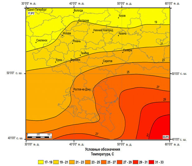
The paper presents the results of the analysis of trends in the average monthly air temperature, arid lands of the European part of Russia and the territories associated with them, in the summer period, as well as estimates of their direction and speed of temperature changes in the second half of the twentieth and early twenty-first centuries. Against the background of the global climate, the regional features of the thermal regime of the European territory of Russia (ETR) are studied. The analysis of latitudinal and longitude quantitative indicators of changes in the thermal regime, with a spatial distribution in the study area, is given. A significant increase in air temperature was found in the territories of arid lands of Russia, where the trend of temperature increase is significantly higher than the data presented in the Assessment Reports and amounted to 0.066oC over 10 years.

Keywords: air temperature, global climate, European territory of Russia, thermal regime, arid lands, trend, variability.

DOI: 10.24412/1993-3916-2021-4-3-12

QUANTITATIVE CLIMATE INDICATORS AS APPLIED TO THE ASSESSMENT OF HYDROTHERMAL CONDITIONS IN THE REPUBLIC OF KALMYKIA

Arid Ecosystems

Shumova N.A. QUANTITATIVE CLIMATE INDICATORS AS APPLIED TO THE ASSESSMENT OF HYDROTHERMAL CONDITIONS IN THE REPUBLIC OF KALMYKIA // Arid ecosystems. 2021. V.27. № 4 (88). P. 13-24. | PDF

The study is aimed at studying the reliability of estimates of the dynamics of hydrothermal conditions in the Republic of Kalmykia for the period 1966-2017, obtained based on the use of quantitative climate indicators, namely, the Selyaninov hydrothermal coefficient, the moisture coefficient, the Thornthwaite aridity index, the Köppen method and the Holdridge scheme. The analysis of the results obtained showed that the greatest reliability is inherent in climatic estimates made on the basis of the Selyaninov hydrothermal coefficient, the Köppen method and the Holdridge scheme. The estimates made using the Thornthwaite aridity index do not reflect the current climatic conditions of the study area and are unreliable.

Keywords: quantitative indicators of climate, natural zones, regional level, Republic of Kalmykia.

Financing.  This research was carried out within the state assignment of Water Problems Institute of the Russian Academy of Sciences, Section 2.6 “Evolution of Terrestrial Ecosystems under the Changing Natural Conditions”, Theme “Modeling and Forecasting of the Processes of Water and Ecosystems Quality Restoration under Various Scenarios of Climate Change and Anthropogenic Activities” No. 0147-2018-0002, state registration No. АААА-А18-118022090104-8.

DOI: 10.24412/1993-3916-2021-4-13-24

ANALYSIS OF HYDROTHERMAL CONDITIONS IN THE ROSTOV REGION IN THE PERIOD 1960-2019

Arid Ecosystems

Gudko V.N., Usatov A.V.,  Azarin K.V. ANALYSIS OF HYDROTHERMAL CONDITIONS IN THE ROSTOV REGION IN THE PERIOD 1960-2019 // Arid ecosystems. 2021. V.27. № 4 (88). P. 25-31. | PDF

Based on data from six meteorological stations in the Rostov region in the period 1960-2019, the tendencies of changes in air temperature, precipitation, and hydrothermal conditions, expressed by the Selyaninov hydrothermal coefficient, were analyzed. For all meteorological stations, a significant trend was determined for the increase in the average annual air temperature and the sums of temperatures above 10 °C. The annual amount of precipitation had a significant upward trend only at the Chertkovo meteorological station, at the other five meteorological stations — an upward trend. On the background of an intensive increase in temperatures, a tendency for a decrease in the values of the Selyaninov hydrothermal coefficient for the Gigant, Rostov-on-Don, Taganrog and Tsimlyansk meteorological stations was noted. At the meteorological stations Chertkovo and Remontnoye, the increase in temperatures was compensated by an increase in the amount of precipitation; as a result, a tendency to an increase in the values of the Selyaninov hydrothermal coefficient was noted. Hydrothermal conditions at six meteorological stations in the period 1960-2019 were characterized as dry, and the mean annual value of HTC varies within 0.64 — 0.82. The driest conditions are typical for meteorological stations located in the east and north-east of the Rostov region. Based on the calculated trends, it can be concluded that in the period 1960-2019 for the meteorological stations Gigant, Rostov-on-Don, Taganrog and Tsimlyansk, arid warming is characteristic, while the meteorological stations Remontnoye and Chertkovo are characterized by humid warming.

Keywords: air temperature, precipitation amount, hydrothermal conditions, Selyaninov hydrothermal coefficient, arid warming, humid warming, Rostov region.

Financing. The work was carried out with the financial support of the Ministry of Science and Higher Education of the Russian Federation within the framework of the state assignment in the field of scientific activity (No. 0852-2020-0029).

DOI: 10.24412/1993-3916-2021-4-25-31

SEMIARID INTERMONTANE DEPRESSONS OF THE NORTHERN CAUCASUS: LANDSCAPES AND LAND USE TRANSFORMATION

Arid Ecosystems

Petrushina M.N., Gunya A.N. SEMIARID INTERMONTANE DEPRESSONS OF THE NORTHERN CAUCASUS: LANDSCAPES AND LAND USE TRANSFORMATION // Arid ecosystems. 2021. V.27. № 4 (88). P. 32-40. | PDF

On the basis of long-term field studies in semiarid intermontane depressions of the North Caucasus, the features of their landscape structure and modern changes in landscapes associated with different levels of anthropogenic load have been revealed since the end of the 20th century. In the Itum-Kalinskaya depression, due to the termination of intensive economic use (mainly grazing) in the early 1990s, the pressure on landscapes decreased and the restoration of their biogenic components began. This led to the suspension of aridization, which was noted by many authors in the 1970s-1980s. In mountain meadow-steppe landscapes, the destruction of cultural and landscape elements (plow terraces, irrigation system, etc.) is taking place. In the Bylym Basin, with a general decrease in anthropogenic load in the 1990s, an extreme unevenness of its distribution was noted, which led to the degradation of some landscapes and an improvement in the state of others. The load on mountain-steppe landscapes has increased, which gradually transformed into anthropogenic modifications. The strongest anthropogenic disturbances are observed in landscapes on the slopes of the northern exposure, which are adjacent to the main residential and economic zone and are used almost all year round. The contrast between landscapes with different levels of use is increasing, mainly due to the greater pressure on them near settlements, while the landscapes distant from them may not be used at all.

Keywords: semi-arid depressions, North Caucasus, land use transformation, landscape change, landscape structure.

Financing. The work was carried out on the topic of the State Task of the Department of Physical Geography and Landscape Studies of Moscow State University «Factors and processes of spatio-temporal organization of natural and anthropogenic landscapes» (Contract no. 1.8, CITIS number — 121051300176-1), as well as on the topic of the State Task of the Institute of Geography of the Russian Academy of Sciences (No. 0148-2019-0007) «Assessment of physical-geographical, hydrological and biotic environmental changes and their consequences for creating the foundations of sustainable nature management».

DOI: 10.24412/1993-3916-2021-4-32-40

ASSESSING ANTHROPOGENIC PRESSURE OF FOREST VILLAGES IN SEMI-ARID FOREST ECOSYSTEM IN WESTERN INDIA USING CUMULATIVE DISTURBANCE INDEX (CDI)

Arid Ecosystems

Rasal V., Dhakad M., Khandal D. ASSESSING ANTHROPOGENIC PRESSURE OF FOREST VILLAGES IN SEMI-ARID FOREST ECOSYSTEM IN WESTERN INDIA USING CUMULATIVE DISTURBANCE INDEX (CDI) // Arid ecosystems. 2021. V.27. № 4 (88). P. 41-49. | PDF

Human communities living in and around the forest are highly dependent on the forest for subsistence and livelihood. Kailadevi Wildlife Sanctuary (KWLS), is an important landscape for securing tiger population in semi arid western India. Human population and their livestock residing in KWLS are exerting anthropogenic pressure on the habitat. Understanding the nature of the anthropogenic pressure is essential to mitigate anthropogenic pressure, reduce negative human-wildlife interactions and improve habitat for wildlife. Anthropogenic disturbance caused by 12 enclave villages inside KWLS was measured using cumulative disturbance index (CDI). Livestock grazing and extraction of wood was found to be the most pressing anthropogenic pressures in the KWLS. Outcome of the study will help the forest managers to devise strategies to improve the habitat quality for the wildlife.

Keywords: anthropogenic pressure, cumulative disturbance index (CDI), Kailadevi wildlife sanctuary.

DOI: 10.24412/1993-3916-2021-4-41-49

FORMATION OF THE WATER REGIME ON THE SANDS OF THE ARCHEDINSKO-DON MASSIF DEPENDING ON THE PLANT COMMUNITIES DISTRIBUTION

Arid Ecosystems

Kulik A.K., Kulik K.N., Vlasenko M.V., Sukhorukikh Yu.I., Biganova S.G. FORMATION OF THE WATER REGIME ON THE SANDS OF THE ARCHEDINSKO-DON MASSIF DEPENDING ON THE PLANT COMMUNITIES DISTRIBUTION // Arid ecosystems. 2021. V.27. № 4 (88). P. 50-58. | PDF

The remote monitoring of the territory and the Archeda-Don interfluve sand massif landscape-ecological instrumental profiling made it possible to determine the soil and vegetation cover state, the level and slopes of groundwater. The soils salinization degree on various sands types was revealed. The water-soluble salts amount is 0.001% on open sands in the blowing hollows, and 0.03-0.05% on chernozem-like soils. Massifs where plant litter is accumulated have a salinity of 0.05-0.07%. Natural forest stands consist of the following species: birch (Bétula), alder (Alnus), oak (Quércus), aspen (Pópulus trémula) and willow (Sálix). In the XIX century, the common pine (Pínus sylvéstris) was introduced into the culture. A large number of forest sites and their koloks-like placement caused by the close occurrence of groundwater. Maximum productivity is achieved by alders (Alnus) with a wood reserve of 500 m3/ha. Their height in areas with stagnant ground water reaches 12-15 m. The birch trees (Bétula) koloks are located on depressions. On clay areas there are rare stands of petiolate oak (Quércus róbur) with a height of 8-12 m. The pine (Pínus sylvéstris) growth on chernozem-like multiphase sandy loam soils and on single-phase overgrown sands with thick turf-steppe soils is shown. There were identified 5 dominant sand types, where the area of forage lands is 171536 ha and forest sites – 50584 ha. All sand types have forest sites in the form of koloks and pine crops. Overgrown tuberous-ridge (seropeski) sands are in dominant. The total grass productivity according the sand types on 170625 hectares of pasture land of the massif is 370.7 thousand hectares. The most productive are overgrown closed depressions and ancient watercourses (3.0 t/ha). The received research results are relevant for a conceptual model of sandy lands optimal use development.

Keywords: sandy soils; salinity; soil moisture; vegetation; forest massifs; forest cover; forage lands.

Financing. The work was carried out on the topic of research of the Federal Scientific Center for Agroecology, Integrated Land Reclamation and Protective Afforestation of the Russian Academy of Sciences No. AAAA19-119042290014-5 «Theoretical foundations of water resources management in the forest-agrarian development of arid territories of the Russian Federation on the basis of a dynamic model of the water balance of the region, mathematical modeling of the processes of formation and dynamics of groundwater and surface waters, assessment of the impact of climate change and anthropogenic loads on the agro-resource potential and forest conditions».

DOI: 10.24412/1993-3916-2021-4-50-58

HUMUS STATUS OF SOILS OF ARCHAEOLOGICAL MONUMENTS OF THE EARLY IRON AGE (REPUBLIC OF BASHKORTOSTAN)

Arid Ecosystems

Kungurtsev A.J., Suleymanov R., Ovsyannikov V.V., Savelyev N.S., Abakumov E.V., Asylbaev I.G. HUMUS STATUS OF SOILS OF ARCHAEOLOGICAL MONUMENTS OF THE EARLY IRON AGE (REPUBLIC OF BASHKORTOSTAN) // Arid ecosystems. 2021. V.27. № 4 (88). P. 59-69. | PDF

The organic matter of modern and buried humus horizons of soils has been studied on the example of the archaeological monuments Akberdinskoe-II, Shipovskoe and Okhlebininskoe-II settlement (Kara-Abyz culture of the early Iron Age of the IV century BC — the turn of the II-I centuries BC). Archaeological sites are located on the territory of the Iglinsky district of the Republic of Bashkortostan within the forest-steppe zone. Morphological and physico-chemical properties of soils are determined. Additionally, methods of spectrophotometry and 13C NMR spectroscopy were used. On the territory of archaeological sites, dark gray forest soils of loamy granulometric composition are common. The thickness of the daytime and buried humus horizons of soils is 11-30 cm . Organic matter is represented by fulvate-humate, humate and humate-fulvate types of humus. The group composition is dominated by humic acids, and among the fractions of humic acids – the fraction of GC-2. The results of spectrophotometry showed a more mature state of the aromatic part of humic acid molecules for buried humus horizons compared to modern humus horizons. Humic acid molecules of the organic matter of modern humus horizons, according to the results of 13C NMR spectroscopy, correspond to the conditions of the chernozem type of soil formation. In general, the modern intensification of climate aridization in the forest-steppe zone of the Republic of Bashkortostan originates, according to archaeologists, from the middle of the IV century BC and the turn of the II-I centuries BC In the soil cover of archaeological sites at the time of observation of the change in the type of soil formation was not found.

Keywords: organic matter, archaeological monument, buried soils, Kara-Abyz culture, forest-steppe.

Funding. This research was carried out within the state assignment of the Ministry of Science and Higher Education of the Russian Federation (Ufa Federal Research Centre of the Russian Academy of Sciences) No. 075-00326-19-00, Theme “Studying the Risks of Soils Desertification in the Steppe Zone of the South Ural Region: Factors, Trends and Development of Ways to Reduce Its Negative Consequences” No. AAAA-A18-118022190102-3; and supported by the Russian Foundation for Basic Research, Project No. 17-11-02001-OGN “Cultural and Historical Processes and Changes of the Natural and Climatic Conditions during the Early Iron Age in the Forest-Steppe Territory of Aral Region” (Institute of History, Language and Literature of Ufa Federal Research Centre of the Russian Academy of Sciences). The humic acids were studied in the Scientific Park of Saint Petersburg State University (“Magnetic-Resonance Research Methods” and “Methods for Analysis of Matter Composition” resource centers).

DOI: 10.24412/1993-3916-2021-4-59-69

CURRENT STATE CRAMBE EDENTULA FISCH. & C.A. MEY. EX KORSH. ON THE PLATO OF USTURT IN UZBEKISTAN

Arid Ecosystems

Rakhimova N.K., Rakhimova T., Adilov B.A., Tamambetova Sh.B., Polvonov F.I. CURRENT STATE CRAMBE EDENTULA FISCH. & C.A. MEY. EX KORSH. ON THE PLATO OF USTURT IN UZBEKISTAN // Arid ecosystems. 2021. V.27. № 4 (88). P. 70-76. | PDF

The article is devoted to the assessment of the state of the ontogenetic structure of the rare species Crambe edentula Fisch. & C.A. Mey. ex Korsh., growing in the Karakalpak part of Ustyurt. The study showed that in the ecological-cenotic conditions of Ustyurt, the studied cenopopulations are normal, mostly incomplete. The characteristic ontogenetic spectrum for C. edentula is centered due to an increase in the life span of individuals in a mature generative state and poor seed renewal. Ontogenetic spectra of cenopopulations do not coincide with the characteristic one. The spectra of specific cenopopulations are left-sided and right-sided, which is associated with ecological habitat conditions and fluctuations in weather conditions.

Keywords: Ustyurt plateau, infrastructure development, endemics, rare plant species, ontogenetic structure, age and efficiency of cenopopulations.

DOI: 10.24412/1993-3916-2021-4-70-76

DISTRIBUTION OF STEPPE MARMOT ON THE RUSSIAN PLAIN IN THE HISTORTICAL PAST: CARTOGRAPHIC REVIEW

Arid Ecosystems

Rumiantsev V.Yu. DISTRIBUTION OF STEPPE MARMOT ON THE RUSSIAN PLAIN IN THE HISTORTICAL PAST: CARTOGRAPHIC REVIEW // Arid ecosystems. 2021. V.27. № 4 (88). P. 77-85. | PDF

Changes in distribution of steppe marmot (Marmota bobak Müll.) during the history time always aroused and are of interest to specialists. Available studies give the information about the sites of marmot meetings as lengthy text descriptions that causes difficulties for perception and analysis of material. Solution of this problem is possible using the modern cartographic methods. In present work we generalized the known information about historical distribution of steppe marmot in cartographic form using the actual GIS technologies. The further analysis of results will enable to clarify significantly the details of steppe marmot distribution on the Russian plain during the history period – especially because of natural features of marmot preferred habitats.

Keywords: Steppe marmot, Marmota bobak Müll., Russian plain, sites of historical locations, cartographical methods, GIS technologies.

Acknowledgement. The author is sincerely grateful to V.A. Tatarsky for providing a copy of the map of V.A. Chernaya and for many years of friendly cooperation in the study of marmots. The author is also grateful to D.A. Khitrov and A.A. Golubinsky for effective and fruitful cooperation in processing the materials of the General Survey

DOI: 10.24412/1993-3916-2021-4-77-85

NUMBER OF BREEDING IN THE TERRITORY OF THE ROSTOVSKY RESERVE OF PELICANS (PELECANIDAE) AND THE CAUSES OF FLUCTUATIONS IN NUMBERS

Arid Ecosystems

Malinovskaya Y.V., Minoranskiy V.A. , Kolesnikov S.I. NUMBER OF BREEDING IN THE TERRITORY OF THE ROSTOVSKY RESERVE OF PELICANS (PELECANIDAE) AND THE CAUSES OF FLUCTUATIONS IN NUMBERS // Arid ecosystems. 2021. V.27. № 4 (88). P. 86-92. | PDF

There were estimated a population size and nesting sitesof Dalmatian pelican (Pelicanus crispus) and Great White Pelican (Pelicanus onocrotalus) on Rostov Nature Reserve territory since 1995 to 2020. Establishing the reserve enabled the conservation of the bird species on the territory. The Dalmatian pelican is a near threatened and regularly nesting species and the Great White pelican is the least concern and rarely nesting species what can be explainedby their biological features. In the research there was made a nesting places specification. The research shows that drying out waters, increasing of water salinity, fish resources reduction could be defined as a deterrent factors for population size of the pelican species.

Keywords: Rostov Nature Reserve, Pelecanus crispus, P. onocrotalus, nesting sites, abundance, limiting factors.

Acknowledgement. The authors were assisted in conducting research by the staff of the Rostov Nature Reserve (A.V. Chekin, L.V. Kletz, A.D. Lipkovich, S.V. Moskalenko, etc.), employees of the Association (V.I. Dankov, A.G. Borodin, etc.) and the SFU (A.V. Tikhonov, Ya.Yu. Podgornaya, etc.), to whom the authors bring sincere gratitude.

DOI: 10.24412/1993-3916-2021-4-86-92

Навигация по записям

← Предыдущие записи

About the Journal

  • General Information
  • Open Access 
  • Preprint
  • Topics of the journal
  • Editoral Board
  • Editorial Policy
  • Editorial Ethics

Articles Supplying

  • Rules of Manuscripts Supplying
  • Articles Design
  • Article Structure
  • Guidens for Writing an Article
  • Articles Translation

Review of manuscripts

  • Review of manuscripts

Archive

  • 1990s editions
  • 2000s editions
  • 2010s editions
  • 2020s editions
    • Issues for 2020
    • Issues for 2021
    • Issues for 2022
  • Events

_______________________

©2023 - Arid Ecosystems - Weaver Xtreme Theme
↑