UDC 631.671
Kuzmina Zh.V., Shinkarenko S.S., Solodovnikov D.A., Markov M.L. Impact of River Flow Regulation, Climatic and Hydrological Changes on the State of Floodplain and Delta Ecosystems of the Lower Don // Arid Ecosystems. 2022. Vol. 28. № 4 (93). P. 22-36. | PDF
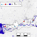
The terrestrial floodplain ecosystems of the Lower Don remain poorly explored even today, despite the fact that almost all of its lower reaches are regulated by water reservoirs and low-pressure hydroelectric facilities, which significantly change ecosystems and landscapes. Our studies were carried out according to our own methodology. The field part was carried out on 5 model ecological profiles, including a detailed study of vegetation and the location of surface groundwater at the model sites. The laboratory studies included the analysis of statistical hydrological materials and Landsat 2, 3, 5 and Sentinel-2 satellite images, as well as the identification of the ecosystems and landscapes state with the help of a two-stage method for assessing disturbances in terrestrial ecosystems and landscapes under the watering regime change. We determined that the main factor that influences the change in the biotic components of the Lower Don ecosystems is the reduction in the fluctuations amplitude of water discharge (and levels) during the annual cycle due to the runoff regulation and climate change. The flooding frequency in the floodplain and delta territories decreased 4 times, along with a 3.5-fold decrease in spring flood discharges, and a 2.2-2.3-fold increase in low-water flows (during winter and summer-autumn periods). It caused a water level rise in the Don channel by 2.5 m and more, as well as a rise and stabilization of the groundwater level in the floodplain and delta of the Lower Don, which replaced the upper and middle floodplains communities with atypical invasive species. The natural forests of oak and elm on the upper floodplain have been replaced by green ash (Ffaxinus pennsylvanica) and ash-leaved maple (Acer negundo) almost entirely. The willow forests (Salix alba), common for the middle floodplain, were replaced by the shrubs of desert false indigo (Amorpha fruticosa) in the near-river floodplain, and with silver berry forests (Elaeagnus angustifolia) in the central parts of the floodplain. The forb meadows of the middle floodplain were replaced by almost monodominant bushgrass (Calamagrostis epigeios) communities with thorny weeds, such as thistle (Cirsium) and cocklebur (Xanthium). The newly formed atypical floodplain communities have better chances to withstand a year-round high level of groundwater. When we evaluated the disturbance of ecosystems and landscapes water level on a 5-point scale from our own methodology, it showed that the least disturbed (2 out of 5) were the territories in the modern and old delta of the Don river, remote from any hydraulic structures. The remaining profiles (3-5) in the zone affected by the hydraulic structures, have an average disturbance level (3 out of 5), which does not yet require a change in the hydrological regime of the river, but suggests for the local hydro- and forest engineering measures to drain the land.
Keywords: Lower Don, change in water discharge, low water, high water, flooding, floodplain, groundwater level, floodplain ecosystems and landscapes, assessment of ecosystem disturbance.
Acknowledgements. The authors would like to thank V.Yu. Georgievsky for his help with obtaining the hydrological data.
Funding. The development and analysis of hypsometric profiles, flooding levels and water surface mapping were funded by the grant of the Russian Science Foundation, project No. 21-77-00018, “Patterns of the Dynamics of River Floodplains Landscapes in the Area of Insufficient Humidity under the Hydrological and Climatic Changes”; analysis of hydrological changes and the floodplain landscapes state are part of the theme No. FMWZ-2022-0002 of the Water Problems Institute of the Russian Academy of Sciences “Research of Geoecological Processes in the Hydrological Land Systems, Formation of the Quality of Surface and Underground Waters, Problems of Water Resource Management and Water Use under the Climate Change and Anthropogenic Impacts”. The field studies are part of the theme No. FNFE-2022-003 of the Federal Scientific Center for Agroecology, Complex Melioration and Protective Afforestation of the Russian Academy of Sciences “Theoretical Basis of Functioning and Natural-anthropogenic Transformation of Agroforestry Landscape Complexes of the Transitional Natural-geographical Zones, Patterns and Forecasting of Their Degradation and Desertification According to the Geoinformation Technologies, Aerospace Methods and Mathematical-cartographic Modeling in Modern Conditions”. The hydrological data were provided as part of the civil law contract on 19/12/2018, No. 78/1-NIR/FCP-2018 for researches aimed to implement the federal special-purpose program “Development of the Water Management Complex of the Russian Federation in 2012-2020”, theme “Scientific Generalization of Hydrological Monitoring Data for a Scientific Reference Book of the Main Hydrological Characteristics of Water Bodies in the Don River Basin”.
DOI: 10.24412/1993-3916-2022-4-22-36
EDN: QDMSBH