↓
 

ISSN 1993-3916

Arid Ecosystems

The “Arid Ecosystems” journal was organized by the decision of General Biology Division of the Russian Academy of Sciences.

  •  Home
  • Preprint
  • Contacts
  • Open Access 
  • Archive
    • Issues 1990s
      • Issues for 1995
      • Issues for 1996
      • Issues for 1997
      • Issues for 1998
      • Issues for 1999
      • Issues for 2000
    • Issues 2000s
      • Issues for 2001
      • Issues for 2002
      • Issues for 2003
      • Issues for 2004
      • Issues for 2005
      • Issues for 2006
      • Issues for 2007
      • Issues for 2008
      • Issues for 2009
      • Issues for 2010
    • Issues 2010s
      • Issues for 2011
      • Issues for 2012
      • Issues for 2013
      • Issues for 2014
      • Issues for 2015
      • Issues for 2016
      • Issues for 2017
      • Issues for 2018
      • Issues for 2019
    • Issues 2020s
      • Issues for 2020
      • Issues for 2021
      • Issues for 2022

Архив метки: desertification

ABOUT THE REGULARITIES OF THE DEVELOPMENT OF THE SOIL COVER OF THE PODGORNY-PRIMORYE PLAINS OF THE WESTERN CASPIAN SEA

Arid Ecosystems

UDC 631.4

Kotenko M.E., Asgerova D.B., Galimova U.M. ABOUT THE REGULARITIES OF THE DEVELOPMENT OF THE SOIL COVER OF THE PODGORNY-PRIMORYE PLAINS OF THE WESTERN CASPIAN SEA // Arid Ecosystems. 2022. Vol. 28. № 4 (93). P. 55-60. | PDF

The Podgorny-Primorye plains are widespread in arid regions of the world. They are forming in the coastal strip, where the mountains come close to the seashore. Unlike other plains, they consist of three specific elements of the foothill plain: piedmont plain, coastal plain, or coast, and the continental part of the region. In these landscape components, soils and vegetation cover differ significantly, changing the structure of the soil cover.

Keywords: seashore, arid soils, piedmont plain, desertification, salt migration, soil salinization, indicator.

DOI: 10.24412/1993-3916-2022-4-55-60

EDN: XUWQOR

THE CURRENT STATE OF THE SALSOLA ARBUSCULIFORMIS, ANABASIS SALSA PASTURES OF KARAKALPAK USTURT (UZBEKISTAN)

Arid Ecosystems

UDC 581.5 (575.13)

Rakhimova N.K., Rakhimova T. THE CURRENT STATE OF THE SALSOLA ARBUSCULIFORMIS, ANABASIS SALSA PASTURES OF KARAKALPAK USTURT (UZBEKISTAN) // Arid ecosystems. 2022. V.28. № 3 (92). P. 61-71. | PDF

The article is devoted to the study of the current state of pastures of the Chernoboyalyshev-Biyurgun (Anabasis salsa, Salsola arbusculiformis) type, common in the territory of Karakalpak Ustyurt (Uzbekistan). The results of field studies of the species composition and productivity of plant communities with the dominance of Salsola arbusculiformis are presented and the reasons for the difference between the obtained data and the data of Karakalpak researchers of the 1970s are discussed. These pastures cover half of the northern and eastern parts of the territory (1,291,414 ha) and are distributed on gravelly, loamy, takyr-alkaline, gypsum soils of the Karakalpak Ustyurt, which includes 4 pasture varieties: shrub-white-earth wormwood-black boletus (Salsola arbusculiformis, Artemisia terrae- albae, Atraphaxis spinosa, Convolvulus fruticosus) with the participation of zaisan saxaul (Haloxylon ammodendron); white-earth sagebrush-black balsam (Salsola arbusculiformis, Artemisia terrae-albae): a) with the participation of Convolvulus fruticosus, Rheum tataricum, Stipa richteriana; b) with the participation of Anabasis brachiata; biyurgun-black balsam (Salsola arbusculiformis, Anabasis salsa) with zaisan saxaul (Haloxylon ammodendron) and shrubs (Salsola arbusculiformis, Atraphaxis spinosa, Convolvulus fruticosus). The area of the studied pasture varieties, the nature of the soil cover, the percentage of projective cover, landscape plant species, their placement, forage yield and recommended seasonality of use were determined. The composition of the vegetation remains monotonous due to complexes of boyalyshev, biyurgun and wormwood communities. Due to the lack of moisture in the year of observation (2021), the dominant species (Salsola arbusculiformis, Artemisia terrae-albae) showed a weak annual growth (up to 1 cm) and they were in a depressed state. The seasonal forage yield of pastures of the Salsola arbusculiformis, Anabasis salsa pastures ranges from 0.5 to 3.5 q/ha, the maximum yield occurs in the autumn period. According to estimates of the yield of the eatable part (c/ha), the studied pasture varieties are recommended to be used as an autumn-winter pasture.

Keywords: Republic of Karakalpakstan, Ustyurt, desertification, pasture difference, degradation, vegetation cover, productivity.

Financing. The work was carried out within the framework of the State Program (PFI-5) «Assessment of the current state of vegetation cover and pasture resources of the Republic of Karakalpakstan».

DOI: 10.24412/1993-3916-2022-3-61-71

SPECTRAL CHARACTERISTICS OF DESERTIFICATED PASTURES OF BLACK LANDS (KALMYK REPUBLIC)

Arid Ecosystems

UDC 631.1: 631.4:631.6:581.5: 528.7:528.8:574.46

Yuferev V.G., Tkachenko N.A., Sinel’nikova K.P. SPECTRAL CHARACTERISTICS OF DESERTIFICATED PASTURES OF BLACK LANDS (KALMYK REPUBLIC) // Arid ecosystems. 2022. V.28. № 1 (90). P. 65-72. | PDF

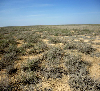
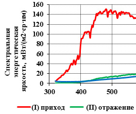
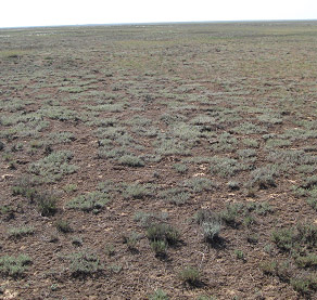
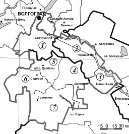
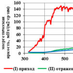
Geosystems of the desert territories of Kalmykia in modern conditions function in conditions of increasing anthropogenic impact and intensity of negative weather events, including the impact of dust storms, which often leads to a significant decrease in pasture productivity, a decrease in the feed base and a significant reduction in livestock. In this regard, it is relevant to determine the spectral characteristics of desert pastures by ground methods, which provides not only the detection of the reflected energy distribution over the spectrum frequencies, which in itself is important for subsequent verification of remote sensing data of pastures, but also the possibility of obtaining the values of normalized indicators, both for plant communities and for specific plants and soil types with the formation of a spatial data base. The objects of the study are the natural phytocenoses of desert pastures of the Black Lands at the landfills: «Smushkovo»,  «Molodezhny», «Privolny», «Dl. Sagi» and «Tavn-Gashun». Geobotanical and spectrometric studies were carried out at these polygons and spatially determined data on the spectral characteristics of plant communities were obtained. Spectrometric studies of phytocenoses are carried out to assess their condition on the basis of spectrosonal surveys, both ground-based and remote. To present the results of the assessment of the spectrometric characteristics of the vegetation cover of the downed pastures: the predominant communities at the landfill and «Tavn-Gashun» were selected: bluegrass with Descurania sofia (Poa bulbosa+Descurainia sophia) with a projective cover of 45%, grasshopper bluegrass (Poa bulbosa-Stipa capillata) – with a projective cover of 40% and open soil (slightly humus sand). The studies were carried out using the PSR-1100 field spectroradiometer. The results of studies of the spectrum of reflected radiation of plant communities and underlying soils allowed us to establish the characteristic features of the distribution of reflected and absorbed energy, to compile a catalog of individual spectra and normalized indicators for them. Individual spectral characteristics were established for the phytocenosis Poa bulbosa+Descurainia sophia, the average value of reflected energy in all spectral ranges is 20.2 MW/(m2×sr×nm), the standard deviation of reflected energy is 9.90, the vegetation index NDVI = 0.208, for Stipa capillata, the average value of reflected energy in all spectral ranges is 20.5 MW/(m2 sr nm), the standard deviation of reflected energy is 12.36, the vegetation index NDVI = 0.316, for Calligonum aphyllum, the average value of reflected energy-the reflected energy in all spectral ranges is 47.2 MW/(m2×sr×nm), the standard deviation of reflected energy is 9.81, the vegetation index NDVI = 0.354. For soil, the average value of reflected energy in all spectral ranges is 30.3 MW/(m2×sr×nm), the standard deviation of reflected energy is 9.28, the vegetation index NDVI = 0.106. The highest average value of NDVI was noted for Calligonum aphyllum.

Keywords: geosystem, analysis, desertification, degradation, spectrometry, satellite images, phytocenoses, verification, vegetation indices, albedo.

Financing. The work was carried out within the framework of the State Task of the Federal Research Center of Agroecology of the Russian Academy of Sciences No. 0713-2019-0001 “To conduct theoretical and geoinformation modeling, monitoring, forecasting of degradation processes of components of agroforestry landscapes based on aerospace research in forest-steppe, steppe and desert zones and to develop ways to manage anti-degradation agroforestry technologies to prevent desertification of lands, increase their fertility and form an ecological framework” (state registration No. AAAAAA-A-116122010038-9).

DOI: 10.24412/1993-3916-2022-1-65-72

PRIORITIES OF THE DEVELOPMENT STRATEGY OF THE WORLDWIDE RESEARCHES OF ARID LANDS

Arid Ecosystems

Zalibekov Z.G., Mamaev S.А., Grinchenko О.S., Kotenko М.Е., Мagomedov R.А. Priorities of the Development Strategy of the Worldwide Researches of Arid Lands // Arid ecosystems. 2020. V. 26. № 3 (84). P. 3-13. | PDF

The assessment of the global state of desertification highlights the need of information describing global extension of arid degradation and  damage it causes. In the context of climate warming, which is noticed at the present time, all new regions will be exposed to drought, weakening the stability of the degraded lands. However the frequency of droughts increases in arid regions with high intensity. The efforts of scientists and practitioners have been reflected in the journal «Arid ecosystems» over the past 25-years, allowed us to obtain final information about the mechanisms of degradation of soils, vegetation and wildlife. Based on the scientific achievements in anthropogenic dynamics of desertification processes and  resource potential of individual components of arid ecosystems, it is necessary to make a reasonable approach to the strategy and identify methods for implementing the presented concepts, programs and projects. Generalization of theoretical positions of  productivity restoration, stability of a soil cover allowed to present fundamental research of the world arid lands as an independent concept of «green economy». Its main specific feature is the differentiation of human impact: natural and medical-biological. The last aspect includes the assessment of the social situation of people living in conditions of increasing droughts, dry spells and climate warming.

Keywords: soil degradation, new stage, research strategy, sustainable development, socio-economic priorities, «green economy», concept revision, desertification, climate change.

DOI: 10.24411/1993-3916-2020-10101

LAND  DEGRADATION NEUTRALITY – THE NEW GLOBAL CONCEPT AND METHODOLOGY FOR THE DRYLANDS RESEARCHING AT NATIONAL LEVEL

Arid Ecosystems

Kust G.S.,  Andreeva O.V.,  Lobkovskiy V.A. LAND  DEGRADATION NEUTRALITY – THE NEW GLOBAL CONCEPT AND METHODOLOGY FOR THE DRYLANDS RESEARCHING AT NATIONAL LEVEL // Arid ecosystems. 2020. V. 26. № 2 (83). P. 3-9. | PDF

The assessment based on the applying of the concept of Land Degradation Neutrality (LDN) and of the method for assessing LDN indicators for Russian drylands is presented for the first time. It is shown that the LDN is not reached wherever in the arid and semiarid regions in Russian Federation, since the proportion of land that is degraded over total land area in 2001-2015 is everywhere positive and ranges from 9 to 67%. The concept of “LDN index” is introduced for making convenient to compare and rank individual territories. An assessment of some arid regions of Russia according to this indicator is provided. The obtained preliminary results need to be validated and refined based on a comparison with the available national data collected by traditional methods.

Keywords: land degradation neutrality, desertification, drylands, land degradation.

DOI: 10.24411/1993-3916-2020-10089

DYNAMICS OF LAND DEGRADATION IN THE ROSTOV REGION

Arid Ecosystems

Bezuglova O.S.,  Nazarenko O.G., Ilyinskaya I.N. DYNAMICS OF LAND DEGRADATION IN THE ROSTOV REGION // Arid ecosystems. 2020. V. 26. № 2 (83). P. 10-15. | PDF

The Rostov region, located in the southeast of the European part of the Russian Federation, is characterized by a temperate continental climate with somewhat unstable humidity levels. Typical summers are dry and hot, while winters have relatively little snow and constant winds. Climatic and geomorphological features of the territory, as well as the high agricultural development of land resources determine the development of a number of deterioration processes. The purpose of the research was to make a comparative spatio-temporal assessment of degradation processes that contribute to the development of the desertification process in the Rostov region. The basis of the research was the analysis of literature and archival data in retrospect, the use of calculated natural and environmental indicators, differentiated study of soil types common for the region and the degree of natural humidity of the agrolandscape in accordance with the ecological stability and hydrothermal regime of the territory. It has been established that the climate aridization, agro-depletion, erosion development are typical for the Rostov Region. This allows for evaluation Rostov region as a territory with a risk of potential desertification.

Keywords: dehumification, agro-depletion, erosion, aridization, desertification.

DOI: 10.24411/1993-3916-2020-10090

GEOINFORMATION ANALYSIS OF DESERTIFICATION IN NORTH-WESTERN PRECASPIAN REGION

Arid Ecosystems

Kulik K.N.,  Petrov V.I.,  Yuferev V.G.,  Tkachenko N.A.,  Shinkarenko S.S. GEOINFORMATION ANALYSIS OF DESERTIFICATION IN NORTH-WESTERN PRECASPIAN REGION // Arid ecosystems. 2020. V. 26. № 2 (83). P. 16-24. | PDF

An analysis of the desertification of the North-Western Precaspian region using geo-information technologies and aerospace data to identify changes in the area of hotspots of desertification showed that the area of degraded and deserted lands increases with the growth in the quantity of sheep and goats. With a relatively stable number of animals, the role of climatic factors increases, which leads to an increase in the speed and amplitude of changes in the area of hotspots of desertification, both in the direction of decrease, with sufficient moisture, and an increase in dry years. Landscape fires have a significant impact, which lead not only to a decrease in the projective cover, but also to the depletion of the species composition of vegetation. The study and mapping of the relief made it possible to establish spatially determined geomorphological features of the territory as a factor affecting local moisture, and, accordingly, on the stability of ecosystems and the possibility of phytomelioration.

Keywords: geographic information systems, analysis, desertification, degradation, mapping, modeling, satellite imagery, hotspots, area, correlation, regression, phytomelioration.

DOI: 10.24411/1993-3916-2020-10091

MELIORATIVE EFFICIENCY OF THE BELT OF SHRUBS ON THE ARID PASTURES OF SOUTHERN RUSSIA

Arid Ecosystems

Tyutyuma N.V., Bulakhtina G.K., Kudryashov A.V., Kudryashova N.I. MELIORATIVE EFFICIENCY OF THE BELT OF SHRUBS ON THE ARID PASTURES OF SOUTHERN RUSSIA // Arid ecosystems. 2020. V. 26. № 1 (82). P. 62-68 . | PDF

In this article we present the long-term study (2008-2018) of the influence of a belt of shrubs on the vegetation cover of semi-deserted and degraded pastures. We investigated the changes of snow cover depth during the winter period, productive soil moisture storage, species composition and arid pastures productivity in the dynamics of growth and development of the belt of shrubs. These experiments were carried out according to the methods developed by the All-Russian Research Institute of Agricultural Afforestation (1973), the All-Russian Research Institute of Forages (2015) and B.A. Dospekhov (1985). In comparison with a natural pasture without belts it was revealed that the snow cover depth was growing 3.5-11 times depending on the increased height of Krascheninnikovia shrubs and the amount of precipitation; soil moisture storage increased by 7.2-9.1 mm in the first 5 years, and by 8.8-24.8 mm when the belt’s height was more than 1 m; in the next 10 years the amount of dominant plant species increased by 4 species in the area with the belt of shrubs; pasture productivity increased 1.3-3.9 times in the 3rd years of Krascheninnikovia shrubs vegetation.

Keywords: phytocenosis of pastures, degradation, desertification, belt of shrubs, productive soil moisture storage.

DOI: 10.24411/1993-3916-2020-10084

EVALUATION OF ECOLOGICAL CONDITION AND PRODUCTIVITY LOSSES OF ARID PASTURES ECOSYSTEMS OF SARPINSKY LOWLAND

Arid Ecosystems

Vlasenko M.V., Kulik A.K., Salugin A.N. EVALUATION OF ECOLOGICAL CONDITION AND PRODUCTIVITY LOSSES OF ARID PASTURES ECOSYSTEMS OF SARPINSKY LOWLAND // Arid ecosystems. 2019. V. 25. № 4 (81). P. 71-81. | PDF

We monitored the pastures ecosystems of the semi-arid zone in Sarpinsky Lowland of Russia and registered some local problems. The experimental data was collected through 1999-2017. It is stated that the present agro-landscape conditions are critical. The degraded pastures account for more than 600 thousands ha (34%), more than the half of which are highly degraded. 35-40%, of the total area of the regional forage grounds (about 1870 thousands ha) are moderately overgrazed, 30-40% are highly overgrazed, and 15-20% are excluded from the agricultural management and have turned into broken sands and abandoned territories. The digression is severely high on the winter (year-round) pastures. The area of open and drift sands has increased to 20-30%. In some districts the pressure on the pastures exceeds the optimal index 5-7 times. Almost all pastures need resting periods and agricultural restoration. Desertification (salinity, erosion and deflation) is a severe problem of the region. As the result of it the productivity loss of the pastures is 1052.7 thousands hwt of feed-units per year. Agroforestry measures have a significant value for preventing of soil erosion and deflation and are considered to be the many-functional, long-term protection factor. A map of forest conditions was composed to achieve the maximal ecological- and economical result of agroforestation; it was based on the agroforestry classification which represents the natural characteristics of the territory and features of its agroforestry developing

Keywords: desertification, deflation, eroding, salinity, pastures, annual productivity loss.

DOI: 10.24411/1993-3916-2019-10075

About the Journal

  • General Information
  • Open Access 
  • Preprint
  • Topics of the journal
  • Editoral Board
  • Editorial Policy
  • Editorial Ethics

Articles Supplying

  • Rules of Manuscripts Supplying
  • Articles Design
  • Article Structure
  • Guidens for Writing an Article
  • Articles Translation

Review of manuscripts

  • Review of manuscripts

Archive

  • 1990s editions
  • 2000s editions
  • 2010s editions
  • 2020s editions
    • Issues for 2020
    • Issues for 2021
    • Issues for 2022
  • Events

_______________________

©2023 - Arid Ecosystems - Weaver Xtreme Theme
↑