↓
 

ISSN 1993-3916

Arid Ecosystems

The “Arid Ecosystems” journal was organized by the decision of General Biology Division of the Russian Academy of Sciences.

  •  Home
  • Preprint
  • Contacts
  • Open Access 
  • Archive
    • Issues 1990s
      • Issues for 1995
      • Issues for 1996
      • Issues for 1997
      • Issues for 1998
      • Issues for 1999
      • Issues for 2000
    • Issues 2000s
      • Issues for 2001
      • Issues for 2002
      • Issues for 2003
      • Issues for 2004
      • Issues for 2005
      • Issues for 2006
      • Issues for 2007
      • Issues for 2008
      • Issues for 2009
      • Issues for 2010
    • Issues 2010s
      • Issues for 2011
      • Issues for 2012
      • Issues for 2013
      • Issues for 2014
      • Issues for 2015
      • Issues for 2016
      • Issues for 2017
      • Issues for 2018
      • Issues for 2019
    • Issues 2020s
      • Issues for 2020
      • Issues for 2021
      • Issues for 2022

Архив метки: medium-scale map

MAPPING RANGELANDS OF WILD UNGULATES IN THE BARSA KELMES NATURE RESERVE (KAZAKHSTAN)

Arid Ecosystems

UDC 581.55(633.2/.3) +528.912 (574.55)

Dimeyeva L.A., Salmukhanbetova Zh.K., Malakhov D.V. MAPPING RANGELANDS OF WILD UNGULATES IN THE BARSA KELMES NATURE RESERVE (KAZAKHSTAN) // Arid Ecosystems. 2022. Vol. 28. № 4 (93). P. 153-162. | PDF

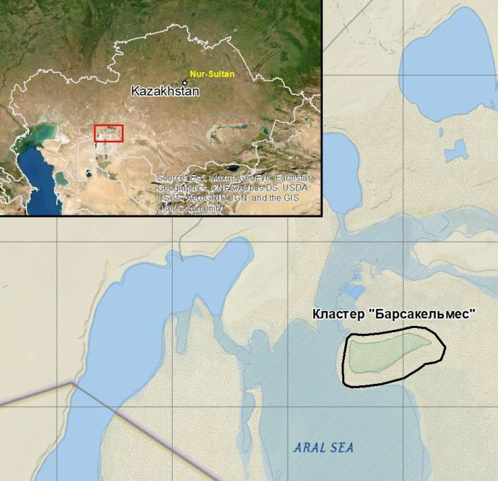
The article presents a medium–scale Rangeland map of the Kaskakulan cluster area in the Barsa Kelmes Nature Reserve, where wild ungulates – kulans, saigas and goitered gazelles live. Ground and remote sensing data were used  to develop the map. The author’s methodology and a set of spectral indices were used processing satellite data. Based on the interpretation of satellite images, maps of seasonal rangeland yields have been developed which were considered in calculating the aboveground phytomass. The legend to the map is a system of headings that take into account zoning, ecological and physiognomic vegetation types and soil conditions. The types of rangelands are reflected in the legend by 15 mapping units, for each the aboveground phytomass for the seasons of the year is given.The map can be used for assessment of forage resourses of the territory and determination of the permissible number of wild ungulates to maintain ecosystems in a balanced state.

Keywords: Aral Sea, forage resourses, remote sensing, yield, medium-scale map.

Financing. The research was carried out with the financial support of the Mikael Zukkov Foundation (ScpFoundation / Greifswald, Germany) through the Association for the Conservation of Biodiversity of Kazakhstan and the International Fund for Saving the Aral Sea in the Republic of Kazakhstan.

DOI: 10.24412/1993-3916-2022-4-153-162

EDN: HLTHXW

About the Journal

  • General Information
  • Open Access 
  • Preprint
  • Topics of the journal
  • Editoral Board
  • Editorial Policy
  • Editorial Ethics

Articles Supplying

  • Rules of Manuscripts Supplying
  • Articles Design
  • Article Structure
  • Guidens for Writing an Article
  • Articles Translation

Review of manuscripts

  • Review of manuscripts

Archive

  • 1990s editions
  • 2000s editions
  • 2010s editions
  • 2020s editions
    • Issues for 2020
    • Issues for 2021
    • Issues for 2022
  • Events

_______________________

©2023 - Arid Ecosystems - Weaver Xtreme Theme
↑