↓
 

ISSN 1993-3916

Arid Ecosystems

The “Arid Ecosystems” journal was organized by the decision of General Biology Division of the Russian Academy of Sciences.

  •  Home
  • Preprint
  • Contacts
  • Open Access 
  • Archive
    • Issues 1990s
      • Issues for 1995
      • Issues for 1996
      • Issues for 1997
      • Issues for 1998
      • Issues for 1999
      • Issues for 2000
    • Issues 2000s
      • Issues for 2001
      • Issues for 2002
      • Issues for 2003
      • Issues for 2004
      • Issues for 2005
      • Issues for 2006
      • Issues for 2007
      • Issues for 2008
      • Issues for 2009
      • Issues for 2010
    • Issues 2010s
      • Issues for 2011
      • Issues for 2012
      • Issues for 2013
      • Issues for 2014
      • Issues for 2015
      • Issues for 2016
      • Issues for 2017
      • Issues for 2018
      • Issues for 2019
    • Issues 2020s
      • Issues for 2020
      • Issues for 2021
      • Issues for 2022

Архив метки: soil salinization

ABOUT THE REGULARITIES OF THE DEVELOPMENT OF THE SOIL COVER OF THE PODGORNY-PRIMORYE PLAINS OF THE WESTERN CASPIAN SEA

Arid Ecosystems

UDC 631.4

Kotenko M.E., Asgerova D.B., Galimova U.M. ABOUT THE REGULARITIES OF THE DEVELOPMENT OF THE SOIL COVER OF THE PODGORNY-PRIMORYE PLAINS OF THE WESTERN CASPIAN SEA // Arid Ecosystems. 2022. Vol. 28. № 4 (93). P. 55-60. | PDF

The Podgorny-Primorye plains are widespread in arid regions of the world. They are forming in the coastal strip, where the mountains come close to the seashore. Unlike other plains, they consist of three specific elements of the foothill plain: piedmont plain, coastal plain, or coast, and the continental part of the region. In these landscape components, soils and vegetation cover differ significantly, changing the structure of the soil cover.

Keywords: seashore, arid soils, piedmont plain, desertification, salt migration, soil salinization, indicator.

DOI: 10.24412/1993-3916-2022-4-55-60

EDN: XUWQOR

SALINIZATION OF SOILS IN THE DON VALLEY UNDER CONDITIONS OF IRRIGATION CESSATION

Arid Ecosystems

UDC 631.4

Gorokhova I.N., Chursin I.N. Salinization of Soils in the Don Valley under Conditions of Irrigation Cessation // Arid ecosystems. 2022. V.28. № 2 (91). P. 102-112. | PDF

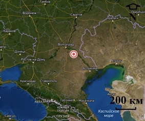
The presented study is aimed at identifying the current salinity state of the soils of the Generalovskiy Irrigation System (IS), built near the Tsimlyansk reservoir (1959) and located in the dry-steppe zone of the Volgograd oblast, in the Don Valley. The system is currently in the conditions of a 30-year period of cessation of irrigation. During the interpolation study, soil salinity maps were created, covering their different depths and based on field survey materials and water extraction data (1:5) of soil samples collected in 2020. Water extraction data obtained in the Volgograd Hydrogeological and Reclamation party (2018) were also used.

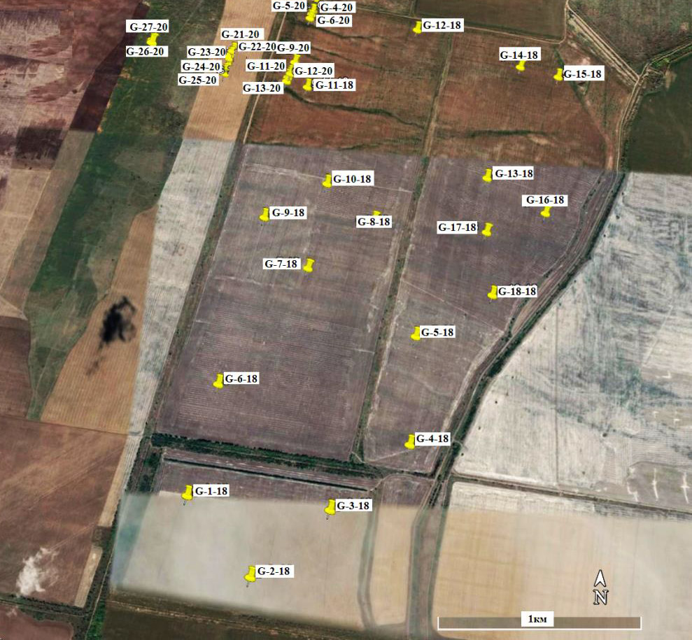
The key plot of the research was located on the 2nd left-bank terrace above the floodplain of the Don River and included the territory where by the beginning of the 1990s, during a long period of irrigation, a high level (1.5-3 m) and strong mineralization (3-10 g/l) of groundwater formed, which led to the forming of meadow solonchak and secondary salinized soils of a strong degree of salinity. This stimulated the salinization mapping of the territory and encouraged us to determine the changes happened during the past period.

The analysis of soil salinity maps made it possible to: assess the current salinity state of soils located on various elements of the topography of the second terrace of the Don River and comparison of the current salt state of soils with the period of the late 1980s and early 1990s, which showed the gradual salinization of previously saline areas and the development of alkalinization of the upper horizons of soils. Soil salinization is caused by the cessation of irrigation, and soil alkalinization is caused by the location of the Generalovskiy IS in the salt zone, a long period of irrigation (1960-1992) and irrigation from the Tsimlyansk reservoir with water with an increased concentration of sodium. Soil salinity maps showing the depth of the salt horizon provide information necessary for the development and selection of optimal reclamation measures to restore soil fertility.

Preliminary recommendations for solving this problem when irrigation is resumed may be: quality control of irrigation water, the use of periodic (every few years) spring water-supply washing of the 0-70 cm layer to push accumulated salts out of the aeration zone, plastering to ensure the displacement of exchangeable sodium, suppression of alkalinity and removal of water-soluble sodium into the underlying horizons beyond the root layer, the use of drip irrigation, an increase in the sharer of perennial legumes and cereals in the structure of planted acreage.

The impossibility of using spectral indices (given in the literature) to determine soil salinity with the help of satellite imagery in relation to the selected research area is shown in the article. A multiple regression analysis was carried out to confirm this. In this analysis, the values of spectral indices in four channels of the Sentinel-2 satellite image and the salinity values of different soil horizons at the sampling points obtained as a result of field and laboratory work were used as features. According to the results of regression analysis, there was no significant relationship between spectral indices and salinity values in all soil horizons. The obtained correlation coefficients were lower than 0.5 and, therefore, the relationship was very low.

Keywords: soil salinization, irrigation system, interpolation method, soil mapping.

Financing. The work was carried out on the topics of state tasks No. 0591-2019-0023 «To study the influence of natural conditions and land use features on the soil cover, including with the participation of saline saline and slitized soils and to develop a technology for assessing the intensity of exploitation of agricultural land soils» and No. AAAAA-A19-119012390065-9 «Development of methods for analysis and integrated use of remote sensing data based on modern geoinformation technologies for monitoring natural landscapes of agricultural lands using groups of small spacecrafts».

Acknowledgement. The authors express their gratitude to the employees of the Volgograd Hydrogeological and Reclamation Party for the data provided for the work.

DOI: 10.24412/1993-3916-2022-2-102-112

DIGITAL PHYTOINDICATION OF SOIL SALINITY IN THE DESERT STEPPES (REPUBLIC OF KALMYKIA)

Arid Ecosystems

Prokopyeva Chr. O., Konyushkova M. V., Novikova N. M., Sobolev I. V. DIGITAL PHYTOINDICATION OF SOIL SALINITY IN THE DESERT STEPPES (REPUBLIC OF KALMYKIA) // Arid ecosystems. 2021. V. 27. № 2 (87). P. 68-81 | PDF

On the territory of the Northern Sarpinsky lowland plain landscape area of the Caspian lowland in the zone of light chestnut soils soil-geobotanic studies were carried out to obtain new data which would allow to estimate the range of variation of soil salinity, which is characteristic for plant species and plant communities of the desert steppe of the Kalmykia Republic, and to calculate the digital models to indicate the degree of soil salinity according to geobotanical data. Along the 64meters-long transect with 1-m step, geobotanical sites, soil digs and wells up to 2 meters deep were laid. In soil samples, the salinity index was measured as pNa in an aqueous suspension (1:5). The results allowed us to determine the quantitative boundaries of soil salinity for 12 plant species and 7 plant communities for 3 depths (0-30, 0-50, 0-100 cm). In relation to soil salinity, three groups of plants were distinguished. The first group includes species confined to non-saline soils with a narrow range of salt content values. The second group has a wide range in terms of salinity and a preference to non-saline soils. The third group includes saline species (halophytes) confined to saline and highly saline soils. Of the 7 plant communities found, two (Stipa lessingiana + Festuca valesiaca + Artemisia lerchiana and Stipa lessingiana + Festuca valesiaca + Tanacetum achilleifolium) are distributed on non-saline soils up to a depth of 2 m; two others (Festuca valesiaca + Artemisia lerchiana + Tanacetum achilleifolium and Artemisia lerchiana + Tanacetum achilleifolium + Artemisia pauciflora) tend to non-saline soils within 0-50 cm, and three (Kochia prostrata + Artemisia pauciflora, Artemisia pauciflora and Poa bulbosa + Anabasis aphylla) are found only on saline soils from a depth of 25-50 cm. Based on data on the presence of plant species as predictors, the CART (decision tree) method predicted the degree of soil salinity with an accuracy of 80% for the 0-30 cm layer, 81% for the 0-50 cm layer, and 64% 0 for the 0-100 cm layer. Significant predictor plants (rank>60) were Kochia prostrata, Tanacetum achilleifolium, Artemisia austriaca, and Festuca valesiaca. Other species have low values of importance (reliability) as predictors.

Keywords: soil salinization, phytoindication, plant species and community, indicators of depth and degree of salinization, importance, reliability, CART and Random forest algorithms, machine learning, communication models, accuracy of indication.

DOI: 10.24411/1993-3916-2021-10152

About the Journal

  • General Information
  • Open Access 
  • Preprint
  • Topics of the journal
  • Editoral Board
  • Editorial Policy
  • Editorial Ethics

Articles Supplying

  • Rules of Manuscripts Supplying
  • Articles Design
  • Article Structure
  • Guidens for Writing an Article
  • Articles Translation

Review of manuscripts

  • Review of manuscripts

Archive

  • 1990s editions
  • 2000s editions
  • 2010s editions
  • 2020s editions
    • Issues for 2020
    • Issues for 2021
    • Issues for 2022
  • Events

_______________________

©2023 - Arid Ecosystems - Weaver Xtreme Theme
↑