

Gorokhova I.N., Pankova Ye.I., Chursin I.N. THE METHODOLOGICAL APPROACHES TO IRRIGATED LANDS STATE ESTIMATION IN THE SOUTH OF EUROPEAN RUSSIA, BASED ON SPACE IMAGERY // Arid ecosystems. 2020. V. 26. № 1 (82). P. 84-93 . | PDF
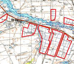
Methodological approaches to irrigated lands monitoring in the south of the European Russia based on satellite imagery from the Landsat-8 satellite are presented. The basis of the methodological approaches was developed on the background of the research experience obtained in the Volgograd region. Visual and automated methods for the irrigated soils interpretation and their properties are shown. As a result of irrigated lands interpretation on the basis of materials from space imagery, the following tasks were solved:1) determination of the areas of irrigated lands; 2) determination of the area of long-term layland on irrigated arrays; 3) determination of the irrigated areas under different crops; 4) determination of the genesis of the low-contrasting soil combinations on irrigated fields, which are, in turn, determined by the state of cultivated crops and soil properties. The conducted work is the first step towards creating of irrigated lands monitoring based on remote sensing. In addition to the above mentioned tasks, the results of the investigation were: the choice of the optimal type and temporal scales of space imagery, the developed interpretation features for the condition of crops and the properties of irrigated soils, the technology of automated interpretation of satellite images for highlighting the spots of irrigated fields based on the «decision trees» algorithm.
Keywords: monitoring, irrigated lands, space imagery, interpretation features, automated classification.
DOI: 10.24411/1993-3916-2020-10087