↓
 

ISSN 1993-3916

Arid Ecosystems

The “Arid Ecosystems” journal was organized by the decision of General Biology Division of the Russian Academy of Sciences.

  •  Home
  • Preprint
  • Contacts
  • Open Access 
  • Archive
    • Issues 1990s
      • Issues for 1995
      • Issues for 1996
      • Issues for 1997
      • Issues for 1998
      • Issues for 1999
      • Issues for 2000
    • Issues 2000s
      • Issues for 2001
      • Issues for 2002
      • Issues for 2003
      • Issues for 2004
      • Issues for 2005
      • Issues for 2006
      • Issues for 2007
      • Issues for 2008
      • Issues for 2009
      • Issues for 2010
    • Issues 2010s
      • Issues for 2011
      • Issues for 2012
      • Issues for 2013
      • Issues for 2014
      • Issues for 2015
      • Issues for 2016
      • Issues for 2017
      • Issues for 2018
      • Issues for 2019
    • Issues 2020s
      • Issues for 2020
      • Issues for 2021
      • Issues for 2022
      • Issues for 2023
      • Issues for 2024
      • Issues for 2025

Архив метки: monitoring

THE STRUCTURE OF THE COENOPOPULATIONS OF DRACOCEPHALUM PEREGRINUM L. IN THE STEPPE COMMUNITIES OF SIBERIA (RUSSIA) IN DIFFERENT YEARS OF THE STUDY

Arid Ecosystems

Denisova G.R., Cheremushkina V.A., Astashenkov A.Yu., Talovskaya E.B. THE STRUCTURE OF THE COENOPOPULATIONS OF DRACOCEPHALUM PEREGRINUM L. IN THE STEPPE COMMUNITIES OF SIBERIA (RUSSIA) IN DIFFERENT YEARS OF THE STUDY // Arid Ecosystems. 2025. Vol. 31. № 2 (103). P. 118-125. | PDF

In this work we study the structure of 4 coenopopulations (CP) of Dracocephalum peregrinum L. located in the steppe communities of Siberia, Russia. We discovered a variety of ontogenetic spectra: left-sided, centered, and bimodal. During the study period, pregenerative individuals accumulated in the ontogenetic spectra of all CPs. The share of the generative fraction in the CP of the Republic of Tuva had increased (CP 2, 3), while decreasing in the mountainous region of Altai (CP 1) and the Republic of Khakassia (CP 4). Structure of spectra changes for various reasons: e.g., a decrease in anthropogenic load (CP 1-4), increase in precipitation (CP 2, 3), growth of shrubs in the cenosis (CP 3), microconditions of the local area (CP 4). Demographic indicators and development speed confirmed the rejuvenation and stability of the studied CPs.

Keywords: monitoring, dynamics, Dracocephalum peregrinum, ontogenetic spectrum, demographic indicators.

DOI: 10.24412/1993-3916-2025-2-118-125

EDN: PMQWSO

SCIENTIFIC BASIS FOR SETTING LAND DEGRADATION NEUTRALITY TARGETS IN TURKMENISTAN

Arid Ecosystems

UDC 502.35;504.052

Kust G.S., Durikov M.H., Lobkovskiy V.A., Andreeva O.V., Nepesov M.D., Mamedov B.K., Nikolaev N.V. SCIENTIFIC BASIS FOR SETTING LAND DEGRADATION NEUTRALITY TARGETS IN TURKMENISTAN // Arid Ecosystems. 2022. Vol. 28. № 4 (93). P. 115-131. | PDF

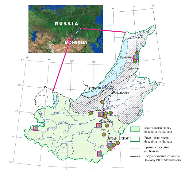
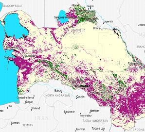
Setting National targets for achieving Land Degradation Neutrality (LDN) and establishing monitoring systems for indicators is an important strategic objective in combating desertification and preventing land degradation in Turkmenistan, arising from the implementation of the UN Sustainable Development Goal 15.3 2030. The paper demonstrates the possibility of integrating of the LDN global indicators in the National Land Cover Monitoring System, which is currently under development, and provided with statistical and geoinformation data for the entire territory of the country. The paper shows how approaches can be developed to integrate the system of LDN indicators into the National Land Surface Monitoring System of Turkmenistan, which is currently under development, with the provision of statistical and geoinformation data for the entire country. Despite important new data obtained using global approaches, a reliable LDN monitoring basing on national data is currently not fully feasible, due to the fact that the global indicators are not sufficiently supported by available national data and do not correspond to global proxy indicators of dynamics land cover, land productivity and soil organic carbon. It is recommended to use cartographic and stock data collected and processed in the late 1980s-90s of the 20th century as a «baseline» for monitoring land degradation, as well as assessment data of the statement of protected areas. Additional and alternative LDN indicators of particular importance for Turkmenistan are proposed: salinization of soil and land, soil deflation, climate aridity, dust storms.

Keywords: Land Degradation Neutrality, Turkmenistan, land degradation, indicators, monitoring.

Financing. The article was prepared within the framework of the project of the GIZ Regional Program «Integrated Land Use taking into account climate change in Central Asia» (ILUCA) – collection of material and preliminary conclusions; topics of the State Assignment of the Institute of Geography of the Russian Academy of Sciences No. FMWS-2022-0001 «Spatial and temporal problems of sustainable land use in the context of global climate change» (spatial data processing and formulation the main provisions and conclusions).

DOI: 10.24412/1993-3916-2022-4-115-131

EDN: LVMDUZ

CAUSE AND EFFECT ANALYSIS OF THE ECOSYSTEM DEGRADATION OF THE BAIKAL BASIN BASED ON LONG-TERM MONITORING IN THE MODEL REFERENCE NETWORK

Arid Ecosystems

Bazha S.N., Andreev A.V., Bogdanov E.A., Danzhalova E.V., Drobyshev Yu.I., Petukhov I.A., Rupyshev Yu.A.,  Ubugunova V.I., Khadbaatar S., Tsyrempilov E.G. CAUSE AND EFFECT ANALYSIS OF THE ECOSYSTEM DEGRADATION OF THE BAIKAL BASIN BASED ON LONG-TERM MONITORING IN THE MODEL REFERENCE NETWORK // Arid ecosystems. 2021. V. 27. № 2 (87). P. 26-32 | PDF

The article outlines the main causes and consequences of the destabilization of ecosystems in the Lake Baikal basin, identified through long-term monitoring. The monitoring is based on a network of model polygons and key sites, established in zones of increased ecological tension, where large-scale mapping is carried out and a complex of landscape and soil-geobotanical studies is carried out. The degree of disturbance of the natural environment of the region is assessed, the main factors of degradation are identified and the nature of degradation processes is established.

Key words: monitoring, ecological mapping, ecosystem degradation, Baikal basin.

DOI: 10.24411/1993-3916-2021-10146

THE METHODOLOGICAL APPROACHES TO IRRIGATED LANDS STATE ESTIMATION IN THE SOUTH OF EUROPEAN RUSSIA, BASED ON SPACE IMAGERY

Arid Ecosystems

Gorokhova I.N., Pankova Ye.I., Chursin I.N. THE METHODOLOGICAL APPROACHES TO IRRIGATED LANDS STATE ESTIMATION IN THE SOUTH OF EUROPEAN RUSSIA, BASED ON SPACE IMAGERY // Arid ecosystems. 2020. V. 26. № 1 (82). P. 84-93 . | PDF

Methodological approaches to irrigated lands monitoring in the south of the European Russia based on satellite imagery from the Landsat-8 satellite are presented. The basis of the methodological approaches was developed on the background of the research experience obtained in the Volgograd region. Visual and automated methods for the irrigated soils interpretation and their properties are shown. As a result of irrigated lands interpretation on the basis of materials from space imagery, the following tasks were solved:1) determination of the areas of irrigated lands; 2) determination of the area of long-term layland on irrigated arrays; 3) determination of the irrigated areas under different crops; 4) determination of the genesis of the low-contrasting soil combinations on irrigated fields, which are, in turn, determined by the state of cultivated crops and soil properties. The conducted work is the first step towards creating of irrigated lands monitoring based on remote sensing. In addition to the above mentioned tasks, the results of the investigation were: the choice of the optimal type and temporal scales of space imagery, the developed interpretation features for the condition of crops and the properties of irrigated soils, the technology of automated interpretation of satellite images for highlighting the spots of irrigated fields based on the «decision trees» algorithm.

Keywords: monitoring, irrigated lands, space imagery, interpretation features, automated classification.

DOI: 10.24411/1993-3916-2020-10087

About the Journal

  • General Information
  • Open Access 
  • Preprint
  • Topics of the journal
  • Editoral Board
  • Editorial Policy
  • Editorial Ethics

Articles Supplying

  • Rules of Manuscripts Supplying
  • Articles Design
  • Article Structure
  • Guidens for Writing an Article
  • Articles Translation

Review of manuscripts

  • Review of manuscripts

Archive

  • 1990s editions
  • 2000s editions
  • 2010s editions
  • 2020s editions
    • Issues for 2020
    • Issues for 2021
    • Issues for 2022
    • Issues for 2023
    • Issues for 2024
    • Issues for 2025
  • Events

_______________________

©2026 - Arid Ecosystems - Weaver Xtreme Theme
↑