↓
 

ISSN 1993-3916

Arid Ecosystems

The “Arid Ecosystems” journal was organized by the decision of General Biology Division of the Russian Academy of Sciences.

  •  Home
  • Preprint
  • Contacts
  • Open Access 
  • Archive
    • Issues 1990s
      • Issues for 1995
      • Issues for 1996
      • Issues for 1997
      • Issues for 1998
      • Issues for 1999
      • Issues for 2000
    • Issues 2000s
      • Issues for 2001
      • Issues for 2002
      • Issues for 2003
      • Issues for 2004
      • Issues for 2005
      • Issues for 2006
      • Issues for 2007
      • Issues for 2008
      • Issues for 2009
      • Issues for 2010
    • Issues 2010s
      • Issues for 2011
      • Issues for 2012
      • Issues for 2013
      • Issues for 2014
      • Issues for 2015
      • Issues for 2016
      • Issues for 2017
      • Issues for 2018
      • Issues for 2019
    • Issues 2020s
      • Issues for 2020
      • Issues for 2021
      • Issues for 2022
      • Issues for 2023

Архив рубрики: article-4-2022

Навигация по записям

Следующие записи →

ARID ZONE UNGULATE SPECIES LISTED IN THE RED DATA BOOK OF THE RUSSIAN FEDERATION

Arid Ecosystems

UDC 599.735.53:591.5

Lushchekina A.A., Karimova T.Yu., Neronov V.M. ARID ZONE UNGULATE SPECIES LISTED IN THE RED DATA BOOK OF THE RUSSIAN FEDERATION // Arid Ecosystems. 2022. Vol. 28. № 4 (93). P. 104-114. | PDF

Over the last hundred years biodiversity has decreased dramatically across the globe.  Currently, there are more than 142,500 species listed in the IUCN Red List, with more than 40,000 species threatened with extinction (The IUCN…, 2022).  Red Data Books of various levels are the lists of rare and threatened species, with the description of their past and present distribution, characteristics of reproduction, and current and needed conservation actions.  Red Data Books provide a formal legal basis for establishing a legally binding framework for the protection of the listed species.

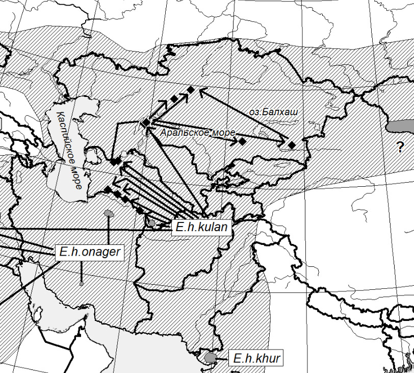
The new edition of the Red Data Book of the Russian Federation (2021) includes four species of ungulates, that play an important role in steppe and desert biocoenoses. Two of them do not occur in the wild in Russia any more–the Przewalski’s horse (Equus przewalskii Poljakov, 1881) since the 19th century and kulan (Equus hemionus Pallas, 1775) since the early 20th century, and the status of saiga antelope (Saiga tatarica Linnaeus, 1766) and the Mongolian gazelle (Procapra gutturosa Pallas, 1777) populations raise the serious concerns.The dropout of members of these species from ecosystems would cause not only the loss of biodiversity of arid bioms but also their degradation.

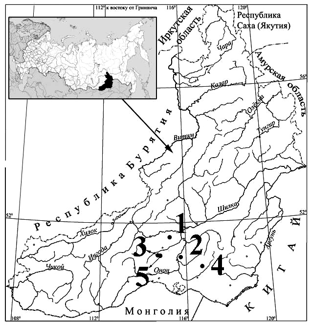
The kulan was for the last time observed in Transbaikalia in Russia in 1926 and plans of this species reintroduction into the wild in Dauria and Transbaikalia have been discussed for almost 20 years, but the implementation of reintroduction project may carry a high level of risks in many aspects. 

The size and status of the Mongolian gazelle population in Russia, at the northern edge of the species natural range, largely depends on the status of the species in Mongolia.  The Mongolian gazelle became extinct in Altai, Tuva, and Transbaikalia in the 1970s–1980s but the growth of the North Kherlen population in Mongolia that began in the 1990s had led to the restoration of winter migrations of the Mongolian gazelle to the South Eastern Transbaikalia, while favourable weather conditions and effective protection measures implemented in two Biosphere Nature Reserves (Daursky and Sokhondinsky) and «the Valley of Dzeren» Federal Reserve had resulted in establishing several resident groups of these ungulates (Kirilyuk, Lushekina, 2017), with the total number of animals currently reaching 20,000 individuals (Kirilyuk, 2021).

It is the first time that the saiga antelope has been included in the Red Data Book of the Russian Federation.  Even in the 1980s, the total population size amounting to about 400 thousand animals did not raise any concern.  However, overhunting, extensive agriculture, loss of suitable habitats, poaching, economic crisis, and suspension of the work of the wildlife conservation authorities all caused the dramatic reduction in saiga numbers in the Northwest Pre-Caspian region that had dropped to 4,000–5,000 individuals by 2015 (Karimova, Lushekina, 2018).

Not long ago, all of these three species were considered as game animals.  However, ecologically unsustainable types of economic development of arid areas (ploughing and reclamation of lands, overgrazing, building of roads and other technical constructions without consideration of regional specifics, etc.) contributed, directly or indirectly, to the decline of the species ranges and affected seasonal migrations and spatial distribution of animals, which eventually resulted in the decline of the populations, increased vulnerability of animals to extreme weather conditions (snowy winters, droughts, wildfires, etc.), and high pressure of legal and illegal hunting.  The future of these unique animals depends primarily on the humans and their attitudes towards their natural environment.  The thriving of these species will be supported by the implementation of measures developed by experts and listed in the Red Data Book of the Russian Federation, as well as in the approved species conservation strategies.

Keywords: Red Data Book, species conservation, the kulan, the saiga antelope, the Mongolian gazelle.

Funding. The work was carried out on the topic of research at the Severtsov Institute of Ecology and Evolution of the Russian Academy of Sciences, State Task No. 1021062812203-8 «Fundamental problems of wildlife conservation and rational use of biological resources».

DOI: 10.24412/1993-3916-2022-4-104-114

EDN: LKRARA

SCIENTIFIC BASIS FOR SETTING LAND DEGRADATION NEUTRALITY TARGETS IN TURKMENISTAN

Arid Ecosystems

UDC 502.35;504.052

Kust G.S., Durikov M.H., Lobkovskiy V.A., Andreeva O.V., Nepesov M.D., Mamedov B.K., Nikolaev N.V. SCIENTIFIC BASIS FOR SETTING LAND DEGRADATION NEUTRALITY TARGETS IN TURKMENISTAN // Arid Ecosystems. 2022. Vol. 28. № 4 (93). P. 115-131. | PDF

Setting National targets for achieving Land Degradation Neutrality (LDN) and establishing monitoring systems for indicators is an important strategic objective in combating desertification and preventing land degradation in Turkmenistan, arising from the implementation of the UN Sustainable Development Goal 15.3 2030. The paper demonstrates the possibility of integrating of the LDN global indicators in the National Land Cover Monitoring System, which is currently under development, and provided with statistical and geoinformation data for the entire territory of the country. The paper shows how approaches can be developed to integrate the system of LDN indicators into the National Land Surface Monitoring System of Turkmenistan, which is currently under development, with the provision of statistical and geoinformation data for the entire country. Despite important new data obtained using global approaches, a reliable LDN monitoring basing on national data is currently not fully feasible, due to the fact that the global indicators are not sufficiently supported by available national data and do not correspond to global proxy indicators of dynamics land cover, land productivity and soil organic carbon. It is recommended to use cartographic and stock data collected and processed in the late 1980s-90s of the 20th century as a «baseline» for monitoring land degradation, as well as assessment data of the statement of protected areas. Additional and alternative LDN indicators of particular importance for Turkmenistan are proposed: salinization of soil and land, soil deflation, climate aridity, dust storms.

Keywords: Land Degradation Neutrality, Turkmenistan, land degradation, indicators, monitoring.

Financing. The article was prepared within the framework of the project of the GIZ Regional Program «Integrated Land Use taking into account climate change in Central Asia» (ILUCA) – collection of material and preliminary conclusions; topics of the State Assignment of the Institute of Geography of the Russian Academy of Sciences No. FMWS-2022-0001 «Spatial and temporal problems of sustainable land use in the context of global climate change» (spatial data processing and formulation the main provisions and conclusions).

DOI: 10.24412/1993-3916-2022-4-115-131

EDN: LVMDUZ

ECOLOGICAL AND ECONOMIC ASSESSMENT OF AGRICULTURAL LAND DEGRADATION IN THE CENTRAL AND WESTERN ZONES OF THE REPUBLIC OF TUVA

Arid Ecosystems

UDC 332.3; 504.5; 504.06

Sambuu A.D., Oxuluk A.O., Kaldar-ool A.Yu. Ecological and Economic Assessment of Agricultural Land Degradation in the Central and Western Zones of the Republic of Tuva // Arid Ecosystems. 2022. Vol. 28. № 4 (93). P. 132-139. | PDF

The presented ecological and economic assessment of agricultural lands of the Republic of Tuva is developed taking into account the theoretical foundations of the economic assessment of the value of land and methods of valuation of environmentally significant factors. According to the agricultural and natural-economic zoning of the East Siberian region, the Republic of Tuva is classified as a steppe sheep-cattle breeding zone. For the purpose of more rational placement and scientifically-based specialization of agricultural production, the territory of Tuva is divided into 4 agricultural zones (Economy of the Tuva ASSR, 1973). The agricultural lands of the research area are included in the Central agricultural zone, mainly agricultural subtayga, livestock-grain steppe, and in the Western agricultural zone, mainly livestock-grain. These are the largest, developed and densely populated parts of the republic, where most of the arable land, 2/3 of hayfields and pastures, more than 80% of the population of the republic are concentrated. The territories of farmland are located within the dry-steppe, steppe and forest-steppe natural and climatic zones. The climate is characterized by the greatest degree of aridity. The main types of soils on arable lands are chestnut sandy loam soils subject to wind erosion – 60%, chernozems – 23% and alluvial turf soils – 15%. The performed assessment shows that the total damage from soil degradation for the Central and Western agricultural zones of the republic is estimated at more than 3.5 billion rubles, which is about a third of the value of the lands belonging to the agricultural lands of the republic. A decrease in the value of land for the period 2012 to 2017 was revealed for the Tandinsky district – 54.1% and the Chedi-Kholsky district – 47.2%, which is associated with soil degradation (according to signs of soil erosion, humus reserves, the content of mobile phosphorus and potassium, the specific area of land experiencing significant anthropogenic loads)..

Keywords: ecological and economic assessment, soil degradation, agricultural zone, depression, Republic of Tuva. 

Financing. The study was carried out with the financial support of the Russian Foundation for Basic Research within the framework of the scientific project No. 19-29-05208\19 mk «Ecological and economic assessment of degradation of agricultural lands of the Republic of Tuva».

DOI: 10.24412/1993-3916-2022-4-132-139

EDN: BJJWSB

FEATURES OF AGRICULTURAL OBJECTS OF ARID TERRITORIES OF NORTH-WESTERN MONGOLIA AND BORDER REGIONS OF TUVA

Arid Ecosystems

UDC 631.417.1 (487)

Prudnikova T.N. Features of Agricultural Objects of Arid Territories of North-Western Mongolia and Border Regions of Tuva // Arid Ecosystems. 2022. Vol. 28. № 4 (93). P. 140-152. | PDF

The author’s long-term research has made it possible to attribute the traditionally pastoral arid territories of Central Asia to the areas of agriculture that was widely developed in the past.

On the territory of Central Mongolia, Tuva, numerous traces of the settled agricultural population are known – for example, the ancient settlements of the early Middle Ages.

The Ubsunur basin with scattered sands and its main watercourse, the valley of the Tes-Khem River, located in the north-west of Mongolia, were not specifically considered earlier from the point of view of the presence of ancient agriculture there.

Nevertheless, the author found traces of a real agricultural civilization on the designated territory. A variety of the irrigation systems, traces of ancient settlements and settlements, features of ancient agricultural landscapes suggest conducting full-fledged studies of the ancient history of that region, studying the consequences of anthropogenic impact on the environment.

The proposed article presents individual agricultural objects, the features of which are of great interest for understanding the history of the development of human civilization both on the territory of the Ubsunur basin, the basin of the Teshem River, and Central Asia as a whole. The work is based on the interpretation of satellite images (Google resources, free access), landscape observations, the use of geological, geographical, archaeological, historical methods, toponymy, complex soil studies. Paleogeographic characteristics are presented on the basis of carpological analyses.

Powerful anthropogenic impact on the environment (deforestation, use of agro-irrigation landscapes for pastures with subsequent overgrazing) it contributed to the degradation of soils, the lowering of groundwater, the formation of desolate landscapes, the extinction of agriculture.

The comprehensive studies of ancient agriculture developed by the author lay the foundations for landscape archaeology of arid territories of Central Asia.

The objects for research are agricultural settlements and irrigation systems in the upper reaches of the Tes-Khem River valley (Mongolia), confined to the zones of young tectonic faults, the field of development of Cenozoic basaltoids, on the absolute altitude about 1700 m, as well as a settlement in its lower reaches, consisting, according to decoding, of small clay structures, not affected by later anthropogenic impact (Mongolia). The study of land plots in the lake area is very informative. Shara-Nur (Ubsunur basin, Tuva), confined to low-lying peat bogs and torn-off soils. Wheat grains were previously found in similar torn-off soils on the territory of neighboring Mongolia.

Powerful anthropogenic impact on the environment (deforestation, use of agro-irrigation landscapes for pastures with subsequent overgrazing) it contributed to the degradation of soils, the lowering of groundwater, the formation of desolate landscapes, the extinction of agriculture.

The comprehensive studies of ancient agriculture developed by the author lay the foundations for landscape archaeology of arid territories of Central Asia.

Keywords: North-Western Mongolia, Ubsunur basin, ancient agricultural objects, traces of settlements, land plots, irrigation canals, Tsetserleg, Shara-Nur, Tes-Khem, Cenozoic volcanism.

DOI:10.24412/1993-3916-2022-4-140-152

EDN:HKTOUP

MAPPING RANGELANDS OF WILD UNGULATES IN THE BARSA KELMES NATURE RESERVE (KAZAKHSTAN)

Arid Ecosystems

UDC 581.55(633.2/.3) +528.912 (574.55)

Dimeyeva L.A., Salmukhanbetova Zh.K., Malakhov D.V. MAPPING RANGELANDS OF WILD UNGULATES IN THE BARSA KELMES NATURE RESERVE (KAZAKHSTAN) // Arid Ecosystems. 2022. Vol. 28. № 4 (93). P. 153-162. | PDF

The article presents a medium–scale Rangeland map of the Kaskakulan cluster area in the Barsa Kelmes Nature Reserve, where wild ungulates – kulans, saigas and goitered gazelles live. Ground and remote sensing data were used  to develop the map. The author’s methodology and a set of spectral indices were used processing satellite data. Based on the interpretation of satellite images, maps of seasonal rangeland yields have been developed which were considered in calculating the aboveground phytomass. The legend to the map is a system of headings that take into account zoning, ecological and physiognomic vegetation types and soil conditions. The types of rangelands are reflected in the legend by 15 mapping units, for each the aboveground phytomass for the seasons of the year is given.The map can be used for assessment of forage resourses of the territory and determination of the permissible number of wild ungulates to maintain ecosystems in a balanced state.

Keywords: Aral Sea, forage resourses, remote sensing, yield, medium-scale map.

Financing. The research was carried out with the financial support of the Mikael Zukkov Foundation (ScpFoundation / Greifswald, Germany) through the Association for the Conservation of Biodiversity of Kazakhstan and the International Fund for Saving the Aral Sea in the Republic of Kazakhstan.

DOI: 10.24412/1993-3916-2022-4-153-162

EDN: HLTHXW

HYDROECOLOGICAL CONDITION OF THE AGRAKHAN BAY AND POSSIBILITIES FOR ITS IMPROVEMENT

Arid Ecosystems

UDC 556.545, 574.5, 639.2/3

Magritsky D.V., Goncharov A.V., Moreido V.M., Samokhin M.A., Abdusamadov A.S., Kuptsov S.V., Dzhamirzoev G.S., Erina O.N., Sokolov D.I., Arkhipkin V.S., Tereshina M.A., Surkov V.V., Semenova A.A. Hydroecological Condition of the Agrakhan Bay and Possibilities for Its Improvement // Arid Ecosystems. 2022. Vol. 28. № 4 (93). P. 163-178. | PDF

In the XX century, as a result of a combination of natural and anthropogenic factors, there was a significant transformation of the Agrakhan Bay on the eastern coast of the Terek Delta. The comprehensive studies carried out in 2018-2020 made it possible to identify the main causes of this degradation, characterize the current state of the reservoir and scientifically substantiate recommendations for its improvement. It is shown that as a result of shallowing and reduction of the area of the water mirror, the bay has lost its former significance as a spawning and growing reservoir that provides the Western Caspian region with young valuable commercial fish species. Catches by 2018 fell by 10 times compared to the beginning of the XX century; sturgeon, which used to be famous for the Agrakhan Bay, practically disappeared. Especially unfavorable is the state of the northern part of the bay, which has turned into a group of shallow reservoirs, little connected with each other and with the sea. And the situation continues to deteriorate every year.

The study of hydrological-morphological, hydrobiological, fishery, hydrochemical parameters showed that there is hope for improving the condition of wetlands on the site of the former bay. A detailed analysis of the water balance using multivariate limnological calculations showed that there is sufficient water for flooding and partial restoration of water bodies of the hydrographic system of the Agrakhan Bay. Clearing silted and overgrown channels, deepening and collapsing of preserved reservoirs, directing the necessary volumes of river water to the Northern and Southern Agrakhan (in accordance with the calculated supply schedule), will reduce overgrowth and siltation of water bodies, restore water exchange between them, improve water quality, revive the fisheries of the region, improve the habitat conditions of many rare and protected animal species, increase the recreational attractiveness of the region.

Keywords: Agrakhan Bay, Caspian Sea, fisheries, degradation of the bay, water quality, ecological condition, ecological rehabilitation, spawning-growing reservoirs, rare species, hydrological modeling.

Financing. The collection and analysis of materials was carried out under a state contract with the West Caspian STB No. NIR-18-01. The preparation of the article was carried out within the framework of the research of the Department of Land Hydrology of the Geographical Faculty of Lomonosov Moscow State University, carried out within the framework of the state task (CITIS number: 121051400038-1).

DOI: 10.24412/1993-3916-2022-4-163-178

EDN: IBMCGO

COMPARATIVE EVALUATION OF HEMATOLOGICAL PARAMETERS OF FEMALE COPEPODS (POLYODON SPATHULA WALBAUM, 1792) WHEN PRODUCING MATURE OOCYTES FOR FOOD AND FISH BREEDING PURPOSES

Arid Ecosystems

UDC 639.311; 591.111.1

Sudakova N.V., Elnakib M.A., Rabazanov N.I. COMPARATIVE EVALUATION OF HEMATOLOGICAL PARAMETERS OF FEMALE COPEPODS (POLYODON SPATHULA WALBAUM, 1792) WHEN PRODUCING MATURE OOCYTES FOR FOOD AND FISH BREEDING PURPOSES // Arid Ecosystems. 2022. Vol. 28. № 4 (93). P. 179-188. | PDF

The study is aimed at assessing the state of reproductive function by fish-hematological and morphophysiological indicators of female copepods Polyodons pathula (Walbaum, 1792), which have repeatedly matured and given caviar for food and fish-breeding purposes. The work was carried out in 2019-2020 in the scientific and experimental aquaculture complex «BIOS» in the Astrakhan region. It has been established that the age of fish, the number of ripening and internerest periods are the most important factors that made it possible to compare the fish-biological indicators of female copepods that matured and gave caviar in 2020. The stability of the fatness coefficient explains the degree of reproductive activity of female copepods. There are no significant differences in morphophysiological parameters between age groups, as well as between females from which caviar of various purposes was obtained. Analysis of the leukocyte blood formula of the studied female copepods showed more lymphoid character and viscoelastic properties of leukocytes, as well as cell agglutination properties were noted when separate blood components were separated. The distribution of white blood cell types differed slightly depending on age composition (CV = 35.55 and 35.23%, P < 0.05, CV = 23.96 and 30.92%, P < 0.05, 23 and 18 years, respectively). The results of hematological studies showed that the younger generation (18 years) of female copepods from which caviar was obtained for nutritional purposes is more adapted than older ones (23 years), and the development of reproductive function is less susceptible to stress factors during maturation. A different picture is observed for fish that gave caviar for fish breeding purposes.

Keywords: female copepods, age of maturation, internerest periods, caviar yield, hemoglobin, total serum protein, leukocyte formula, reproductive function.

DOI: 10.24412/1993-3916-2022-4-179-188

EDN: JBHNPI

HYDROCHEMISTRY AND HYDROBIOLOGY OF THE TECHNOGENIC RESERVOIRS OF MINING TERRITORY IN THE SOUTHEASTERN TRANSBAIKALIA

Arid Ecosystems

UDC 574.583+574.635+550.42(571.55)

Afonina E.Yu., Tashlykova N.A., Zamana L.V., Kuklin A.P., Chechel L.P., Abramova V.A. HYDROCHEMISTRY AND HYDROBIOLOGY OF THE TECHNOGENIC RESERVOIRS OF MINING TERRITORY IN THE SOUTHEASTERN TRANSBAIKALIA // Arid Ecosystems. 2022. Vol. 28. № 4 (93). P. 189-200. | PDF

Water bodies of anthropogenic genesis, as a special component of the technogenic landscape, are characterized by ecological conditions that differ from natural ones. There are limited catchment area, low thickness of bottom sediments, and high content of metals, metalloids and solids. The objects of our study are various lacustrine formations formed during the development of mineral deposits in Eastern Transbaikalia. In present paper, the hydrochemical composition and hydrobiont species diversity and structure have been characterized by technogenic reservoirs of mining territories, different in formation and their purposes. Algae and zooplankton of technogenic water bodies in the arid region are being studied for the first time. The investigated waters of technogenic reservoirs have various morphometric, physical and chemical characteristics with a wide range of pH values (2.99–8.80), total dissolved solids (85.9–9065 mg/l), ore and accompanying elements. By chemical composition, water relates to sulfate and bicarbonate-sulfate one with different ratios of magnesium and calcium. The algal flora and zooplankton species diversity in the studied water bodies is low (75 taxa of plankton algae, 8 taxa of macroalgae, 63 species and subspecies of plankton invertebrates), which is obviously associated with the extreme ecological conditions, where the species richness is a consequence of the influence of physical and chemical conditions of the habitat. The micro- and macro-component composition, total mineralization are the determining factors for the Cryptophyta abundance and biomass and the content of bicarbonates determines the density of Cyanobacteria, Bacillariophyta, Chrysophyta, Charophyta, Chlorophyta, Euglenophyta, Dynophyta. Quantitative indicators of zooplankton are positively related to the concentration of ammonium nitrogen (for Crustacea) and negatively to pH (Rotifera).

Keywords: deposit, technogenic water bodies, hydrochemical composition, phytoplankton, macroalgae, zooplankton.

Financing. The work was carried out within the framework of the state task of fundamental scientific research, state registration no. 121032200070-2.

DOI: 10.24412/1993-3916-2022-4-189-200

EDN: JMGUYF

COMMUNITIES OF PLANKTON AND BENTOS ALGAE OF HIGHLY MINERALIZED RIVERS TRIBUTARIES OF LAKE ELTON

Arid Ecosystems

UDC 582.26.574.2

Gorohova O.G., Zinchenko T.D. COMMUNITIES OF PLANKTON AND BENTOS ALGAE OF HIGHLY MINERALIZED RIVERS TRIBUTARIES OF LAKE ELTON // Arid Ecosystems. 2022. Vol. 28. № 4 (93). P. 201-210. | PDF

The results of long-term (2008, 2012-2019) studies of phytoplankton and phytobenthos of seven highly mineralized rivers of the Elton region are presented. The flora of algae includes 214 taxa from 7 systematic divisions, Bacillariophyta are leading in terms of species richness and quantitative development. A comparative description of the taxonomic structure and species diversity of communities in the mineralization gradient is given. Structure-forming species were identified as widespread euryhaline taxa: Chaetoceros muelleri Lemm., Conticribra weissflogii (Grun.) S.-Suchoples et Williams, Nitzschia closterium Ehr., Halamphora coffeaeformis (Ag.) Meresch., Achnanthesbrevipes Ag. (Bacillariophyta), and also Cyanoprokaryota – Phormidium breve (Kütz. ex Gom.) Anagn. & Kom., Oscillatoria limosa Ag. ex Gom., O. tenuis Ag. ex Gom., Geitlerinema amphibium (Ag. ex Gom.) Anagn. Under conditions of critical salinity for rivers, species of the genus Dunaliella (Chlorophyta) dominate. It is shown that the abundance and biomass of algae in algocenoses vary widely and do not depend on the level of mineralization. Specific species richness is characterized by a weak negative correlation with mineralization in mesohaline rivers and significant (R = -0.50, R = -0.52, p < 0.05) in polyhaline rivers. The seasonal dynamics of plankton algocenoses is expressed in changes in the species structure, abundance, and biomass.

Keywords: salt rivers, Lake Elton, algocenoses.

Financing. The work was carried out as part of the state task «Assessment of Modern Biodiversity and Forecast of Its Changes for the Ecosystems of the Volga Basin in the Conditions of Their Natural and Anthropogenic Transformation» (AAAAA-A17-117112040040-3), with the financial support of the Russian Fundation for Basic Research (17-04-00135).

DOI: 10.24412/1993-3916-2022-4-201-210

EDN: JMKBDF

Навигация по записям

Следующие записи →

About the Journal

  • General Information
  • Open Access 
  • Preprint
  • Topics of the journal
  • Editoral Board
  • Editorial Policy
  • Editorial Ethics

Articles Supplying

  • Rules of Manuscripts Supplying
  • Articles Design
  • Article Structure
  • Guidens for Writing an Article
  • Articles Translation

Review of manuscripts

  • Review of manuscripts

Archive

  • 1990s editions
  • 2000s editions
  • 2010s editions
  • 2020s editions
    • Issues for 2020
    • Issues for 2021
    • Issues for 2022
    • Issues for 2023
  • Events

_______________________

©2023 - Arid Ecosystems - Weaver Xtreme Theme
↑