↓
 

ISSN 1993-3916

Arid Ecosystems

The “Arid Ecosystems” journal was organized by the decision of General Biology Division of the Russian Academy of Sciences.

  •  Home
  • Preprint
  • Contacts
  • Open Access 
  • Archive
    • Issues 1990s
      • Issues for 1995
      • Issues for 1996
      • Issues for 1997
      • Issues for 1998
      • Issues for 1999
      • Issues for 2000
    • Issues 2000s
      • Issues for 2001
      • Issues for 2002
      • Issues for 2003
      • Issues for 2004
      • Issues for 2005
      • Issues for 2006
      • Issues for 2007
      • Issues for 2008
      • Issues for 2009
      • Issues for 2010
    • Issues 2010s
      • Issues for 2011
      • Issues for 2012
      • Issues for 2013
      • Issues for 2014
      • Issues for 2015
      • Issues for 2016
      • Issues for 2017
      • Issues for 2018
      • Issues for 2019
    • Issues 2020s
      • Issues for 2020
      • Issues for 2021
      • Issues for 2022

Архив метки: soil

BIODIVERSITY AND ECOLOGICAL CHARACTERISTICS OF ORIBATID MITES IN THE SOUTH-WEST OF THE KOPETDAG

Arid Ecosystems

UDC 595. 42 (235.132)

Khydyrov P.R. BIODIVERSITY AND ECOLOGICAL CHARACTERISTICS OF ORIBATID MITES IN THE SOUTH-WEST OF THE KOPETDAG // Arid ecosystems. 2022. V.28. № 3 (92). P. 101-106. | PDF

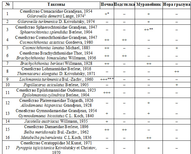
The results of studies on the biodiversity and ecology of mites inhabiting the South-West of the Kopetdag are presented. In particular, 41 species of oribatid mites have been identified in the soil, litter under trees and shrubs, as well as in anthills and holes of rodents, including 3 new species for the fauna of Turkmenistan.

The significance of these mites in the decomposition of plant residues and in soil-forming processes is shown. In the mountains the oribatid mites are capable of life from the second half of March to the end of November. It was found that from mid-May to October, the number of mites in the deserts and steppes reaches its peak of individuals 25-30 ekz./. The lowest indices of the number of oribatid mites were recorded in June specimens 2-7 ekz./ this is explained by the lack of moisture and food resources in the soil. The observations revealed the optimal value of moisture content 5-25% and soil temperature +3 — +25 0C   for the development of mites.

Our research has revealed, for the first time, the breeding centers of mites in anthills. Two ecological groups of myrmecophilic mites have been identified: detritus-phages and zoonecrophages. Myrmecophilic detritus phages were assigned to 14 species of mites that were found in the nests of ants feeding on the seeds of herbaceous plants. The group of myrmecophilic zoonecrophages includes 6 species of mites. They are found in the nests of ants that feed on the corpses of insects.

We examined also the data on the finding of oribatid mites in the holes of rodents. The identification of nidicolous species of oribatid mites is considered as a result of their adaptation to arid habitat conditions.

Keywords: mite, soil, biodiversity, mountain, ecology, ant, rodent.

Financing. The work was carried out on the topic of the State assignment of the Department of Biology of the S. Seidi Turkmen State Pedagogical Institute «Biodiversity of soil mites of various systematic groups (Acari: Sarcoptiformes, Trombidiformes) and their ecology» (No. 10.00.2313).

DOI: 10.24412/1993-3916-2022-3-101-106

USE OF HOLOCENE DEPOSITS OF THE SOUTH-EAST ROSTOV REGION TO ESTABLISH THE ANCIENT ANTHROPOGENIC ACTIVITY IN STEPPE REGIONS

Arid Ecosystems

UDC 550.4; 551.8 (925.22)

Idrisov I.A.,  Shishlina N.I. USE OF HOLOCENE DEPOSITS OF THE SOUTH-EAST ROSTOV REGION TO ESTABLISH THE ANCIENT ANTHROPOGENIC ACTIVITY IN STEPPE REGIONS // Arid ecosystems. 2022. V.28. № 3 (92). P. 107-116. | PDF

Study of the beam system of the rivers Sal and  Don in the south-east of the Rostov region of Russia allowed us to establish a significant area of distribution and a wide variety of Holocene deposits. They accumulated depending on the local features of various sites, the features of exogenous processes, landforms, the nature of soil-forming rocks and other factors. As a result of the study, Holocene deposits in negative relief forms (in the floodplain and the first floodplain terrace) formed by alluvial and deluvial processes with a certain role of

aeolian processes were identified; Holocene sediments of the second floodplain terrace of the end of the Khvalynsky stage of the Caspian Sea and the Novoevksinsky stage of the Black Sea; the intermediate form is Holocene sediments in saucer-shaped depressions. The history of accumulation of deposits on negative and positive relief elements is due to the presence of contrasting stages of environmental changes. The revealed Holocene deposits of different ages were confined to archaeological artifacts that record short-term habitats of mobile cattle breeders of different eras. They were found near identified Holocene deposits. This makes it possible to identify and further study the «invisible» sites of ancient man and obtain additional data on the anthropogenic impact on steppe resource areas in antiquity.

Keywords: paleogeography, Holocene, beam, soil, steppe, River Don.

Financing. The study was supported by the Russian Science Foundation, grant No. 21-18-00026 «Resources and humans in the Bronze Age and the Middle Ages: the dynamics of the use of arid regions of southern Russia» (research supervisor N.I. Shishlin).

DOI: 10.24412/1993-3916-2022-3-107-116

TRENDS IN HYDROTHERMAL INDICATORS OF THE STEPPES OF SOUTH-EASTERN TRANSBAIKALIA IN THE CONTEXT OF CLIMATE WARMING

Arid Ecosystems

Davydova N.D. TRENDS IN HYDROTHERMAL INDICATORS OF THE STEPPES OF SOUTH-EASTERN TRANSBAIKALIA IN THE CONTEXT OF CLIMATE WARMING // Arid ecosystems. 2022. V.28. № 1 (90). P. 3-10 . | PDF

One of the problems of the development of society on Earth was climate change due to the increase in the temperature of the surface layer of air, which for different regions was and remains not equal. The analysis of long-term data on air temperature, atmospheric precipitation and humidity of deep-frozen powdery-carbonate chernozems of the Onon-Argun steppe of South-Eastern Transbaikalia is carried out. It is shown that the next dry period of 1999-2020 differs from the previous one by a significant increase in temperature and an ambiguous annual amount of precipitation. According to these indicators, it is divided into two parts: very dry warm and wet very warm. In the driest period (2001-2011), the moisture reserves in the soils were mostly at the level of withering humidity and below. In nature, there were such catastrophic phenomena as the widespread drying of stands of trees, the disappearance of lakes, including a large one-Barun-Torey. Since 2012, the amount of precipitation has increased, but has had little effect on the soil moisture reserves and the replenishment of the water volume in the lakes. As a result, by 2018, the water area of another large lake of the Torey depression – Zun-Torey-disappeared. The bottoms of the dried-up lakes turned into soda-sulfate sodium and soda- chloride-sulfate sodium salt marshes. In the terrestrial grassland of the steppes, the introduction of xerophilic species into the communities was observed, as well as a decrease in its height and density. The amount of aboveground plant mass decreased by 1.5-2.0 times.

Keywords: global warming, Onon-Argun steppe, atmospheric precipitation, air temperature, humidity, soil, lake drying, vegetation, xerophilic species, stand of trees.

Acknowledgement. The author is grateful to the head of the Borzya meteorological station, L.I. Karpikova, hydrologist O.V. Perminova and all the employees who worked in different years for their long-term assistance in the selection of materials, consultations, understanding and warm friendly attitude, as well as Ph.D. L.V. Dudareva, who took a direct part in the formation of the Chemical Analytical Center of the Institute of Geography of the SB RAS and its accreditation, the development of the instrument base and the receipt of KHA data.

Financing. The work was carried out at the expense of the state assignment of the IG SB RAS, state registration No. AAAA17-117041910171-7, “Spatial and temporal patterns of the material state of the landscapes of Siberia in changing environmental conditions”.

DOI: 10.24412/1993-3916-2022-1-3-10

ACCUMULATION OF HEAVY METALS BY PLANTS OF THE GENUS ACHILLEA L. IN THE ARID CONDITIONS OF THE PLAIN ZONE OF DAGESTAN

Arid Ecosystems

UDC 574.2:582.998.2 (470.67)

Semenova V.V., Anatov D.M. ACCUMULATION OF HEAVY METALS BY PLANTS OF THE GENUS ACHILLEA L. IN THE ARID CONDITIONS OF THE PLAIN ZONE OF DAGESTAN // Arid ecosystems. 2022. V.28. № 1 (90). P. 98-105. | PDF

Received September 8, 2021. After  revisiou September 15, 2021. Accepted October 11, 2021

In the flat zone of Dagestan, arid mixed grasses steppes are common. As part of their herbage, yarrow plants are present, forming extensive thickets in the lowlands. For the first time in Dagestan, the accumulation of heavy metals in the organs of plants of the genus Achillea L. and in soils was studied. The content of Fe, Mn, Pb, Cd in the aboveground and underground mass of plants of the genus Achillea L. was determined in natural and anthropogenic disturbed areas, as well as in the soils on which they grow. It has been established that the accumulation and distribution of heavy metals in plant organs is influenced by pollution from motor vehicles. In Achillea nobilis plants selected in Uchkent and Stalskoye villages, the cadmium content exceeds the maximum permissible level by 1.2-1.7 times. According to the calculated coefficients of biogeochemical mobility, it was revealed that plants of anthropogenically disturbed habitats are characterized by a high accumulation of Fe, Cd, but low – Mn, Pb.

Keywords: Achillea millefolium L., Achillea nobilis L., Achillea biebersteinii Afan., heavy metals, aboveground and underground mass of plants, soil, pollution.

Financing. This work was carried out in the Laboratory of Soil and Plant Resources of the Caspian Institute of Biological Resources of the Russian Academy of Sciences, state assignment No. 0205-2016-0003 “Dynamics of Soil Cover and Ecosystems Bioproductivity in the Northwestern Caspian Region and Eastern Caucasus” (state registration No. АААА-А17-117081640024-6), and it was also funded by the Program of the Russian Academy of Sciences Presidium, No. 1.21 “Biological diversity of natural systems. Biological Resources of Russia: Assessment of their condition and basics of Monitoring”.

DOI: 10.24412/1993-3916-2022-1-99-106

IMPACT OF ENVIRONMENTAL CONDITIONS ON THE SOIL PROCESSES OF THE HIGHLANDS OF DAGESTAN

Arid Ecosystems

Alichaev M.M., Sultanova M.G. IMPACT OF ENVIRONMENTAL CONDITIONS ON THE SOIL PROCESSES OF THE HIGHLANDS OF DAGESTAN // Arid ecosystems. 2021. V.27. № 3 (88). P. 61-65.

The article presents the materials of route, stationary soil, soil-ecological studies conducted in the high-mountain zone of Dagestan with the characteristic: a) the current features of the development of the soil cover; b) the ecological parameters of the soil cover and their changes under the influence of climate warming.

The variety of natural and economic conditions of the object of study caused a significant diversity of the soil cover. The distribution of the soil was greatly influenced by the height of the terrain, the exposure and the steepness of the slopes. Based on the soil erosion studies conducted in previous periods, it can be noted that improper land use and climate warming have led to radical changes in the composition of the soil cover in terms of determining indicators – soil erosion.

In recent years, the area of eroded land has doubled, the area with heavily eroded soils-by 1/3. This led to a decrease in the thickness of humus horizons in almost all soils to an average of 20 cm, and the loss of humus reserves in the soils amounted to 60% of the initial content. The presented analysis of the degradation of the soil cover and the established patterns of soil evolution on the slope lands of the highlands serve as a theoretical basis for the reproduction of soil fertility, the preservation of the ecological role of soil protection from erosion and other degradation processes.

Keywords: soil, fertility, erosion, exposure, highlands, vegetation, ecology, pastures, elevation.

Funding. This work was carried out within the state assignment No. 0733-2019-0005 “To Develop an Assessment System for Modern Trends of Soil Processes Development in Natural Landscapes of the Mountainous Province of the Republic of Dagestan”.

DOI: 10.24411/1993-3916-2021-10164

SEASONAL DYNAMICS OF THE UNDERGROUND PART OF THE EPHEMERAL-WORMWOOD SEMI-DESERT OF THE KURA-ARAZ LOWLAND IN MODERN CLIMATIC CONDITIONS

Arid Ecosystems

Ganiyeva S.A., Gurbanov E.A. SEASONAL DYNAMICS OF THE UNDERGROUND PART OF THE EPHEMERAL-WORMWOOD SEMI-DESERT OF THE KURA-ARAZ LOWLAND IN MODERN CLIMATIC CONDITIONS // Arid ecosystems. 2021. V. 27. № 1 (86). P. 54-61. | PDF

This article discusses the patterns of the dynamics of the underground part of the ephemeral-wormwood semi-desert of the Kura-Araz lowland in conditions of climate change. It was found that regardless of the plant development phase, season of the year and climate change conditions in different years, the ratio of productive and unproductive roots of plants remains at a certain level. The authors of the article determine the objects and methods of research that were conducted by them in different time periods in different climatic conditions. The authors provide figures and data (in tables) illustrating repeated experiments and observations. On the basis of scientifically grounded descriptions, the authors come to the conclusion that with the deepening into the soil, a decrease in the root mass in plant communities occurs with a pronounced regularity.

Keywords: climate change, ephemera, wormwood, root system, underground phytomass, soil.

DOI: 10.24411/1993-3916-2021-10137

TO THE QUESTION OF THE INDICATOR OF SOILS ASSIMILATION POTENTIAL AS A COMPOSITE PART OF THE SOIL PASSPORT AND LANDSCAPES ASSIMILATION POTENTIAL

Arid Ecosystems

Ismailov N.M., Najafova S.I., Kayserovskaya F., Gasymova A.S. TO THE QUESTION OF THE INDICATOR OF SOILS ASSIMILATION POTENTIAL AS A COMPOSITE PART OF THE SOIL PASSPORT AND LANDSCAPES ASSIMILATION POTENTIAL // Arid ecosystems. 2020. V. 26. № 1 (82). P. 69-75 . | PDF

Using the complex comparative soil-biological method for the first time, the average annual assimilation volumes of hydrocarbon pollution in the main soil types of various bioclimatic landscape zones of Azerbaijan were evaluated. The results of the research allowed, in the first approximation, to identify regions with potentially the highest (mountain brown, chestnut and mountain black soils) and the most vulnerable assimilation potential − gray-brown and gray soil. The results of the conducted studies show the possibility and necessity of introducing in the “Soil Passport” indicators of soils data on their assimilation potential with respect to a particular pollutant.

Keywords: soil, pollution, assimilation potential, coefficient of mineralization, passport of soils, scientific basis of nature management.

DOI: 10.24411/1993-3916-2020-10085

QUALITATIVE AND QUANTITATIVE CHARACTERISTICS OF HUMUS HORIZONS OF CRYO-ARID SOILS IN THE BARGUZIN VALLEY

Arid Ecosystems

Ubugunova В.I., Gunin P.D.,  Ubugunov V.L., Aleskerova E.N., Bazha S.N., Ayushina T.A. QUALITATIVE AND QUANTITATIVE CHARACTERISTICS OF HUMUS HORIZONS OF CRYO-ARID SOILS IN THE BARGUZIN VALLEY // Arid ecosystems. 2019. V. 25. № 4 (81). P. 82-91. | PDF

We studied various types of arid soils, forming under the influence of extra continental climate on the northern border of Central Asian steppes distribution. In this article we present the results of color characterization and humus condition of the surface horizons of steppe soils and soils of forest and steppe connection zone. Using  Munsell color system and color spectrum of CIE–L*a*b* system, we determined that cryo-humus accumulation prevails in steppe ecosystems soils and light-humus connection zone. The correlation between labile and bio-inert fractions of humus compounds can be used as a diagnostic parameter. We made a cluster analysis of humus horizons, using 25 indices. The first cluster combines steppe soils with cryo-humus accumulation, the second cluster combines soils with light-humus accumulation. Soils with AK–BCA–Cca profile were classified as cryo-humus soils. The achieved data can be used as a basis to clarify the classification of cryo-arid soils.

Keywords: soil, humus, accumulation, color characteristics, fraction composition.

DOI: 10.24411/1993-3916-2019-10076

About the Journal

  • General Information
  • Open Access 
  • Preprint
  • Topics of the journal
  • Editoral Board
  • Editorial Policy
  • Editorial Ethics

Articles Supplying

  • Rules of Manuscripts Supplying
  • Articles Design
  • Article Structure
  • Guidens for Writing an Article
  • Articles Translation

Review of manuscripts

  • Review of manuscripts

Archive

  • 1990s editions
  • 2000s editions
  • 2010s editions
  • 2020s editions
    • Issues for 2020
    • Issues for 2021
    • Issues for 2022
  • Events

_______________________

©2023 - Arid Ecosystems - Weaver Xtreme Theme
↑